


A Tale of two pictures
A Tale of two pictures
3/4/2015
I had intended to give this as an oral presentation at the January Council meeting but I was prevented from attending by an illness. The subject cannot wait until April because action is needed immediately. This was a visual presentation which loses some of its power in writing, my apologies.
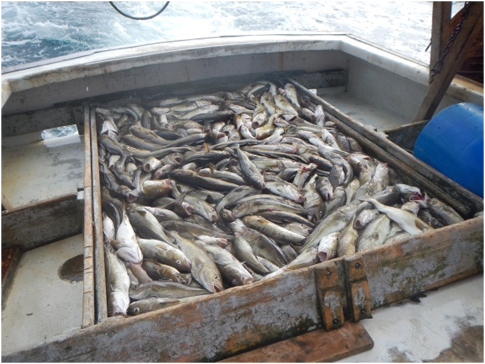
This is a picture of approximately 2000 lbs. of cod. It represents the first time I have targeted cod in two years. While one picture does not determine the status of the stock it is a powerful illustrator of our current assessment shortcomings. This presentation is on Gulf of Maine Cod but the problems it illustrates cut across numerous species. By way of background, this was a one hour research tow in an open area. I travelled 20 miles to make this tow and it represents the first area that had not been taken over by lobster traps. This alone is cause for concern because most of the Gulf of Maine is now defacto closed to commercial fishing and the trawl survey, by the proliferation of fixed gear. The fact is, none of us now know how many cod exist because no one, including the NOAA trawl survey can fish here.
Now, consider the following facts that can be measured from this picture.
- Based on a letter of January 20, 2015 to Groundfish permit holders, from NOAA fisheries, I will be granted sufficient cod to fish 1.3 hours with my three permits. (2742lbs/2000lbs per hour = 1.37 hours)
- One 40 foot boat, such as mine, could catch the entire Gulf of Maine Cod quota in 9.5 days. (456,356 lbs./2000 lbs. per hour = 228.178 hours divided by 24 =9.5 days)
If, as an individual, you think this makes sense, in light of this picture, then read no further.
Read on to learn what clues this picture holds….
Why have you not seen this in commercial tows?
- This tow would be considered a complete failure under sector management.
- The fish pictured here represent about $3000 in December prices
- The cost of leasing these fish (remember you lease the guts and assumed discards also) would be $4000-$4500.
Thus this tow represents a loss of around $1500 to the fisherman. The extortionate price of leased fish is hopelessly skewing fishery dependent data. Until the council deals with the high cost of leased fish across a number of species, fishery dependent data will not be representative of the status of the fishery.
- Why does fishery dependent data matter?
- Fishery dependent data provides much of the information such as length frequency and CPUE that tune most models. Many regions and other entities including ICES, other than New England, use CPUE indices to derive and or tune assessments. Scientists from these entities and regions have been begging for data similar to our study fleet, but here it is not used. Why?
- When did fishery dependent data become altered?
- The advent of closed areas, trip limits, and then sectors began in 1996. A wide array of assessments subsequently suffered large and growing retrospective patterns. I do not believe the two are coincidental!
- NOAA Fisheries state repeatedly that serious age truncation has appeared in the fishery. What does the picture show?
- This picture represents at least four and possibly up to seven different year classes.I willwait for the aging study to be completed because length alone does not determine age in cod. What is remarkable about this picture is that it comes from an area not usually associated with older year classes. Fishermen report seeing, older cod, sometimes over ten years old,further offshore and in deeper waterthen years past. This is just one of the effects of the warming of the waters in the Gulf of Maine which is not being accounted for.
- Why does length frequency change with tow length? Generally, in research tows researchers tow 30 minutes to get a representative sample of the ages present. This is because domed selectivity occurs in which older fish outswim the trawl during haulback. The tow length in the trawl survey was changed from 30 minutes with the Albatross to 20 minutes with the Bigelow, yet NOAA Fisheries refuses to admit domed selectivity exists.
- Council member Peter Kendall has examined the Yankee Fishermen’s Coop landings by market category, large cod, market cod and scrod. During a twenty year period ending in 2014, there is remarkable consistency in the percentage of each group. If there is age truncation, why is it not reflected in the landings?
NOAA Fisheries and the NGO’s, through their press releases, have repeatedly stated fishermen are catching the last huddled masses of cod and go on to compare the Gulf of Maine to Newfoundland. Comparing these two regions is like comparing apples and watermelons. Newfoundland invented icebreaker trawling which targeted spawning aggregations previously protected under the ice. No such technological advance occurred here. The same week I caught these fish, boats doing research in Massachusetts Bay for Massachusetts Division of Marine Fisheries and the Nature Conservancy caught 200-1000 pounds of cod for tows of five minutes to twenty minute in length. These areas included the Olympia tow, top of Stellwagon Bank, edge of the bank, and deep water west of the bank as well as all along the Massachusetts shore. They were unable to make tows of sufficient length to get representative age samples because the entire bay was covered with lobster gear. The only other boat fishing from my harbor had a tow with between 2500 and 4000 pounds of cod for an hour while trying to catch yellowtail ten miles southeast of my location. He pulled the tripper and let the fish swim away because of the 200 pound trip limit imposed by the interim action. Finally an offshore gillnetter fishing on Parker’s, which for those of you who do not know, is closer to the Hague line then the coast of New England, reported an ”idiotic” cod discard rate shoaler then 80 fathoms and only a “disgusting” cod discard rate for the remainder of their five day trip below 80 fathoms. The recreational fishery caught its quota for the year in a month and Gulf of Maine cod continue to be caught in large numbers recreationally off Block Island. So where precisely are these last huddled masses of cod or more precisely, where do you fish not to catch cod?
 This picture was taken the same month in a different year 100 yards from picture one. This is a commercial tow and represents what I caught in December 2014. Why the difference? Picture two has only a few cod and other fish I have to lease. It represents about $800 worth of lobster, finfish and dogfish. The picture illustrates why fishery dependent data has become so skewed by leasing. As a fisherman, I would fish for picture one, but as a businessman I am forced to fish for picture two.
Why else is this picture important? The difference between pictures one and two shows why you cannot rely on a trawl survey for your only source of information. Which picture represents the true status of the stocks? The answer is neither as they are both representative of the same strata. With this kind of variation over 100 yards you cannot expect to accurately measure the biomass, with one tow every roughly 7500 square kilometers.
Very shortly, after May 1, both commercial and recreational fishing will be halted because of the latest flawed assessment. Cod is the poster child, but many other assessments are in a similar state of dysfunction. I request a blue ribbon panel made up of scientists(both NOAA and non-government scientists) and fishermen be put together to set ad hoc interim quotas to be implemented on an emergency basis by NOAA Fisheries while the same group tries to come up with a comprehensive method of proceeding with assessments in the future.
Fishermen have said repeatedly that the science is broken. This is a poor choice of words as fishermen often use science, scientists, and models interchangeably to describe a broken process. The problem, as I have tried to illustrate in this narrative, is that numerous data streams have become incrementally flawed over time. The science and management communities have not been able to holistically examine this problem because they spend all their waking moments trying to meet the mandates of a fatally flawed Magnuson Act. In the early 2000’s Dr. John Boreman, in a meeting over flaws in the trawl survey, stood up and said the system was broken and could not be fixed. This personal courage ushered in a period of cooperation in which we all worked together. Who, in this decade, has the personal courage and integrity to make the same statement so we can all fix a broken process?
Respectfully submitted, David Goethel, F/V Ellen Diane, Hampton, NH
Cover photo courtesy National Fisherman
Cod Photo Credit, Gulf of Maine Research Institute here