


Hermine becomes a hurricane in the Gulf of Mexico
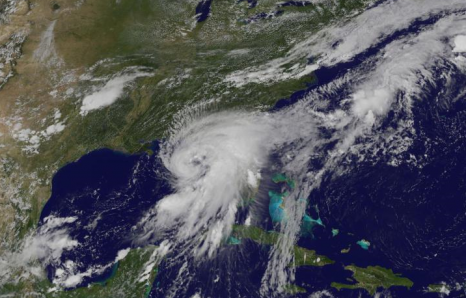
Tropical Storm Hermine officially reached hurricane status on Thursday, Sept. 1, 2016, at 1:55 p.m. EDT. NOAA’s GOES-East satellite captured a visible image of the hurricane at 3:15 p.m. EDT (1915 UTC). The image shows a much more organized Hermine with bands of thunderstorms wrapping around its low-level center and blanketing the entire state of Florida. The image was created at NASA/NOAA’s GOES Project office, NASA’s Goddard Space Flight Center in Greenbelt, Maryland. A hurricane warning is in effect from Suwannee River to Mexico Beach, Florida. A hurricane watch is in effect from Anclote River to Suwannee River, and west of Mexico Beach to the Walton/Bay County line. A tropical storm warning is in effect from Englewood to Suwannee River, from west of Mexico Beach to the Walton/Bay County line, and the Flagler/Volusia County line to Surf City. A tropical storm watch is in effect from north of Surf City to Oregon Inlet, including Pamlico Sound. Read the rest here 18:15


Leave a Reply