Tag Archives: Hurricane Irma
Coast Guard urges mariners to contact watchstanders by phone during VHF outages
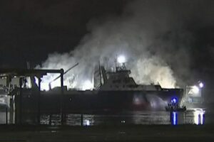
![]() ST. PETERSBURG, Fla. — The Coast Guard requests mariners in life-threatening situations along Florida’s Gulf Coast contact Coast Guard watchstanders by phone during the absence or degradation of VHF radio communications caused by Hurricane Irma. Mariners unable to reach the Coast Guard by VHF radio should use contact Sector St. Petersburg Command Center at 727-896-6187 or 727-896-6188 until radio signals improve or are restored. -USCG- 23:17
ST. PETERSBURG, Fla. — The Coast Guard requests mariners in life-threatening situations along Florida’s Gulf Coast contact Coast Guard watchstanders by phone during the absence or degradation of VHF radio communications caused by Hurricane Irma. Mariners unable to reach the Coast Guard by VHF radio should use contact Sector St. Petersburg Command Center at 727-896-6187 or 727-896-6188 until radio signals improve or are restored. -USCG- 23:17
Hurricane Irma – Massive airborne relief mission en route to Keys to help with ‘humanitarian crisis’
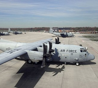 A huge airborne relief mission is en route to the Keys to help people impacted by the devastation caused when the eye of Hurricane Irma blasted through the Lower Florida Keys at daybreak Sunday morning. Monroe County Emergency Management Director Martin Senterfitt called the destruction caused by Irma, a massive Category 4 storm when it impacted the Keys, a “humanitarian crisis.” Among the services coming to the Keys are “disaster mortuary teams,” he said during a conference call. Supplies and personnel could be coming in by air to Monroe County by early Monday morning, Senterfitt said. click here to read the story 17:52
Hurricane Irma Makes Landfall on Marco Island
 3:45 p.m. Hurricane Irma has made landfall on Marco Island, Florida, as a Category 3 hurricane. The National Hurricane Center in Miami said Irma’s powerful eye roared ashore at Marco Island just south of Naples with 115-mph (185-kph) winds, for a second U.S. landfall at 3:35 p.m. Sunday. Category 3 storms have winds from 111 to 129 mph, but 130-mph (21-kph) wind gust was recently reported by the Marco Island Police Department. Irma’s second U.S. landfall was tied for the 21st strongest landfall in the U.S. based on central pressure. Irma’s first U.S. landfall in the Florida Keys was tied for 7th. click here to read the story 16:23
Hurricane Irma activates Jacksonville’s riverfront
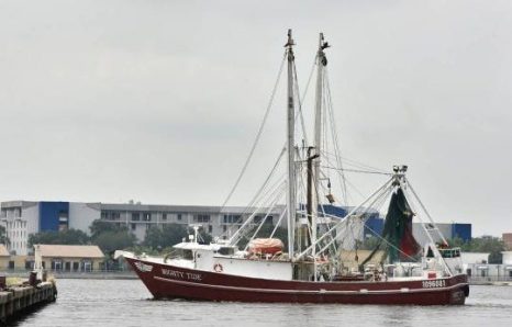
Seeking shelter from Hurricane Irma, the First Coast shrimping and fishing fleet brings a little nostalgia back to the days when downtown Jacksonville was known as being an active working waterfront. In a strange twist of fate, the impending arrival of Hurricane Irma and the long abandoned piers of the defunct Jacksonville Shipyards have resulted in a bit of authentic Jacksonville returning to its historic downtown waterfront. Massive concrete piers built to complement the largest drydocks between Newport News and New Orleans, have become a key player in protecting the First Coast’s shrimping and fishing fleet from Hurricane Irma. click here to read the story 14:16
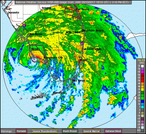
Hurricane Irma – Public Advisory – 1100 AM EDT Sun Sep 10 2017
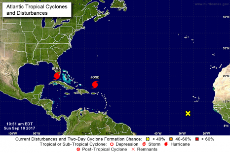
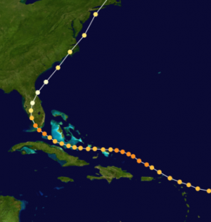
At 1100 AM EDT (1500 UTC), the center of Hurricane Irma was located near latitude 25.0 North, longitude 81.5 West. Irma is moving toward the north near 9 mph (15 km/h, and a north northwestward motion with an increase in forward speed is expected later today, with that motion continuing through Monday. On the forecast track, the eye of Irma should move over the Lower Florida Keys shortly, and then move near or over the west coast of the Florida Peninsula later today through tonight. Irma should then move inland over northern Florida and southwestern Georgia Monday afternoon. click here to read the update. 11:10
Hurricane Irma – Public Advisory – 1100 PM EDT Sat Sep 09 2017
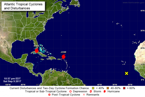
At 1100 PM EDT (0300 UTC), the eye of Hurricane Irma was located near latitude 23.5 North, longitude 81.0 West. Irma is moving slowly northwestward away from the north coast of Cuba near 6 mph (9 km/h). A turn toward the north-northwest with an increase in forward speed is expected through late Monday. On the forecast track, the center of Irma is expected to cross the Lower Florida Keys Sunday morning and then move near or along the west coast of Florida Sunday afternoon through Monday morning. Irma should then move inland over the Florida panhandle and southwestern Georgia Monday afternoon. click here to read the update 23:05
US Waives Jones Act to Secure Fuel for Hurricane Responders
 The U.S. government on Friday said it was temporarily waiving a law that limits the availability of cargoes on the U.S. coasts, a step that will ensure enough fuel reaches emergency responders during Hurricane Irma and in the wake of Hurricane Harvey. The Jones Act mandates the use of U.S.-flagged vessels to transport merchandise between U.S. coasts. The Department of Homeland Security waived the requirement for one week. This will allow oil and gas operators to use often cheaper, tax-free, or more readily available foreign-flagged vessels. click here to read the story 10:03
Hurricane Irma Public Advisory – 0:800 UPDATE from the National Hurricane Center
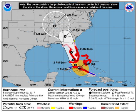
At 800 AM EDT (1200 UTC), the eye of Hurricane Irma was located by a reconnaissance plane and Cuban radars near latitude 22.6 North, longitude 79.5 West. Irma is moving toward the west near 12 mph (19 km/h), along the north coast of Cuba. A northwest motion is expected to begin later today with a turn toward the north-northwest tonight or on Sunday. On the forecast track, the core of Irma will continue to move near or over the north coast of Cuba this morning, and will reach the Florida Keys Sunday morning. The hurricane is expected to be near the southwest coast of Florida Sunday afternoon. click here to read the update AMX Radar NWS Forecast Office Miami – South Florida click here 08:23
Friends Awaiting Word from Missing Lobster Fishermen
 Some lobster fishermen haven’t been heard from in several hours after trying to move traps out of the path Hurricane Irma. According to fellow commercial fisherman, Mike Henry, three or four fishermen had picked up lobster traps and were moving them closer to the Dry Tortugas, about 70 miles west of Key West, where the water is deeper. “They were trying to get them out of the way of the storm and put them out there,” Henry said. The men haven’t been heard from since 10:30 pm Friday night. click here to read the story 07:55
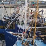
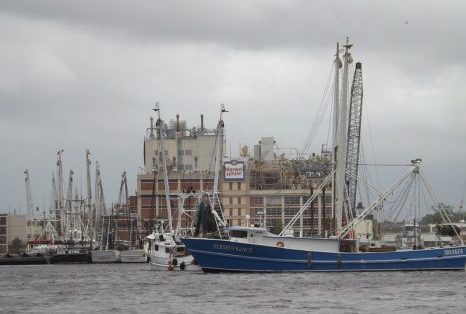
Mayport fishing vessels scramble for docks in Jacksonville in advance of Hurricane Irma
The entire First Coast shrimping and fishing fleet is in the process of moving away from the coast and into a safer docking space in downtown Jacksonville as Hurricane Irma bears down on Florida. While the storm is still churning in the Caribbean, about two dozen shrimp vessels from the Jacksonville area have retracted their nets and are leaving their usual port of Mayport. That’s where Safe Harbor Seafood is the main warehouse and wholesaler of the local catch operates. Gerald Pack, owner of Safe Harbor, said Thursday that shrimp boats and other fishing vessels, usually docked at the historic village about a mile from the mouth of the St. Johns River, have mostly headed to the old Shipyards docks that are girded with concrete near Metropolitan Park. click here to read the story 09:00
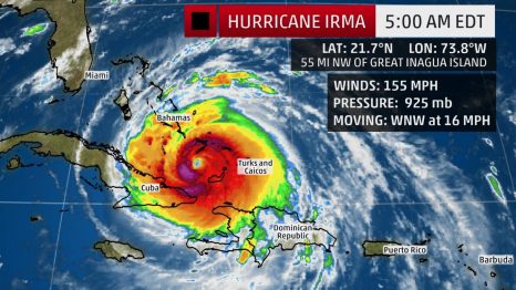
UPDATED: 23:00 Hurricane Irma a Potentially Devastating Category 4 Strike on South Florida Sunday After Raking Through the Bahamas
Hurricane Irma, a potentially catastrophic Category 4 hurricane, is now hammering parts of the Bahamas and Cuba, and will turn its fury on Florida in what is likely to be the state’s strongest hurricane strike since Charley 13 years ago. Below is everything we know about Irma right now, including its latest status, along with potential forecast impacts in the U.S. and the Caribbean Islands. click here to read the story
National Hurricane Center – Hurricane Irma Public Advisory 23:00 update click here 07:38
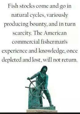
Former NOAA Expert, High-Accuracy Hurricane Predictor Says “Natural Cycles” Major Driver
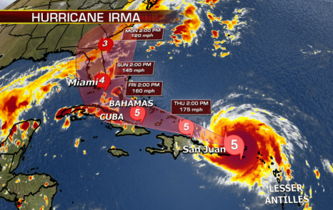
 A former NOAA meteorologist and 40-year veteran of hurricane predictions believes Irma will continue to move move west toward Florida and reach near the southern tip of the Florida Peninsula around Sunday, September 11th, as a major category 4 hurricane. Both David Dilley of Global Weather Oscillations and the National Hurricane Center now believe Irma will make landfall near the southern tip of Florida, from near or just west of Miami to just west or near Jacksonville and then run up the coast into eastern Georgia. Dilley had predicted a harsh hurricane season already back in early February, long before most forecasters were ready to go public with their forecasts.So far his predictions for the current season have been impressively accurate. click here to read the story 10:20
Leaving death and destruction, Hurricane Irma’s storm path: What you should know
Hurricane Irma made landfall in the Caribbean on Wednesday with record winds and powerful waves. The Category 5 storm – the strongest Atlantic hurricane ever recorded north of the Caribbean and east of the Gulf of Mexico – passed over the island of Barbuda overnight. The National Hurricane Center has warned of a growing possibility the hurricane could slam Florida later this week – as Texas and Louisiana are still dealing with the devastating aftermath caused by Hurricane Harvey. Here’s what you should know about Hurricane Irma and its trajectory. click here to read the story Hurricane Irma has killed at least 10 people and injured 23 in French Caribbean island territories as the dangerous Category 5 storm roared over the Caribbean, France’s interior minister said Thursday. click here to read the story 07:23
National Hurricane Center – Hurricane Irma Public Advisory 0:500 click here
Hurricane Irma Passed Over Barbuda as a Potentially Catastrophic Category 5 Hurricane; Dangerous Threat for Florida, Southeast
Hurricane Irma, a dangerous Category 5 hurricane, blasted the island of Barbuda, an island of 1600 residents, with gusts of at least 155 mph. Irma is now heading toward St. Martin, the Virgin Islands, Puerto Rico, Hispañola, the Bahamas and Cuba before posing a serious threat to Florida and parts of the Southeast beginning this weekend. Irma became the strongest hurricane in the Atlantic basin, outside of the Caribbean Sea and Gulf of Mexico, on record on Tuesday morning, according to the National Hurricane Center. click here to read the story 07:37
National Hurricane Center – Hurricane Irma Public Advisory – Discussion and 48-hour outlook click here
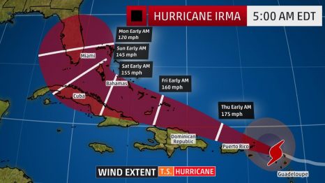
Hurricane Irma a Growing Concern for the U S: Hurricane Warnings Issued For Leeward Islands, Hurricane Watch Hoisted in Puerto Rico
Hurricane Irma is a growing threat to the continental United States, with impacts possibly beginning in Florida later this week. Before that, Irma will bring dangerous conditions to the Leeward Islands, Puerto Rico, Hispaniola, the Bahamas and Cuba. The center of Irma is located 560 miles east of the Leeward Islands and is moving west-southwestward at about 14 mph. Irma is a Category 3 hurricane and satellite imagery shows that it has become better organized in the past day with an eye now clearly evident. click here to read the story 13:44
As Irma intensifies, a disturbance churns in the Gulf of Mexico – click here to read the story Hurricane Irma Public Advisory– National Hurricane Center click here
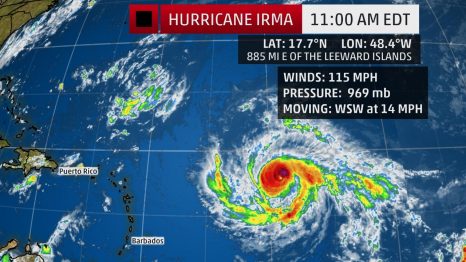
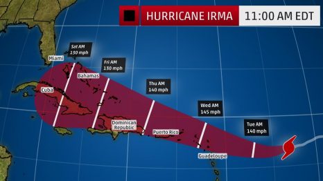
Hurricane Irma Strengthens Into a Category 3; Potential Threat to the Leeward Islands, Puerto Rico, Bahamas and the United States
Hurricane Irma could pose a serious threat for many days to come and all interests from the Leeward Islands and Puerto Rico to the Bahamas and the U.S. East Coast should continue to monitor its progress very closely. The center of Irma is located 885 miles east of the Leeward Islands and is moving just south of due west at about 15 mph. On Sunday morning, Irma strengthened into a Category 3 hurricane. Uncertainty remains surrounding where Irma will track beyond five days due to the complex interaction of Irma with the upper-level weather pattern expected late this week in the western Atlantic and the eastern United States. click here to read the story click here to read National Hurricane Center Forecast Discussion14:59
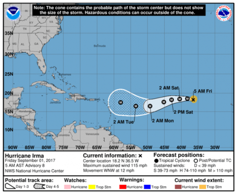
Hurricane Irma holding steady as Category 3 storm in Atlantic
Hurricane Irma was holding steady Friday morning (Sept. 1) as a Category 3 storm in the Atlantic, forecasters with the National Hurricane Center said. It’s unclear what impacts Irma might pose to land. Models are notoriously unreliable more than five days away, and Irma is not expected to near the Leeward Islands until sometime next week. The Leeward Islands are part of the eastern border of the Caribbean Sea. As of Friday morning, the storm was about 840 miles northwest of the Cabo Verde Islands and about 1,665 miles east of the Leeward Islands. It’s moving northwest at 12 mph. It’s expected to turn west again Friday night, followed by a turn to the west-southwest on Saturday. click here to read the advisory 08:29