Tag Archives: Hurricane Jose
Strained Fluke Quotas, Hurricanes and Safe Harbor
 Less than a month after a bill granting vessels safe harbor in New York was signed by Governor Andrew Cuomo, a fishing vessel bound for North Carolina carrying 6,000 pounds of fluke has tested the new policy, straining New York’s federally designated fluke quotas. The F/V Rianda S., which has long been a part of the Montauk fleet, was in transit to land its fish in North Carolina, where it has fishing licenses, on Sept. 17 after fishing in federal waters when it encountered the rough seas generated by Hurricane José and requested safe harbor in Montauk. New York’s fluke fishery is closed for the month of September, due to banner fluke landings this summer that strained the state’s already low federally mandated quotas. click here to read the story 08:25

Jose forces New Bedford fishing fleet to stay in port
The incoming storm has essentially shut down the fishing industry in New Bedford for at least a day or two. Fishermen are not taking any chances with Jose, and it appeared that nobody was heading out onto the water Tuesday morning. Tony Soares, who works for Carlos Seafood, spent the past 24 hours overseeing the massive effort of tying up and securing almost 40 fishing vessels in the Port of New Bedford “I call everybody [and] make sure everybody tied the boats,” said Soares, who was checking the lines by hand around 6 a.m. Tuesday. Video, click here to read the story 09:09

National Hurricane Center – Hurricane Jose Public Advisory
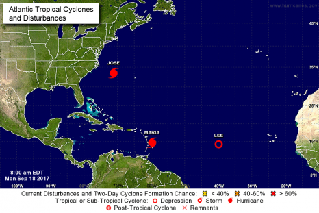
At 800 AM EDT, the center of Hurricane Jose was located by an Air Force Reserve hurricane hunter aircraft near latitude 36.3 North, longitude 71.6 West. Jose is moving toward the north near 9 mph (15 km/h). This general motion is expected to continue through today with a turn to the northeast anticipated tonight. On the forecast track, the center of Jose is forecast to pass well offshore of the Delmarva peninsula later today, pass well to the east of the New Jersey coast on Wednesday, and pass offshore of southeastern Massachusetts by Thursday. click here to read the update 08:12
National Hurricane Center – Hurricane Jose Public Advisory
Interests elsewhere along the U.S. east coast from North Carolina northward to New England should monitor the progress of Jose. At 800 AM EDT, the center of Hurricane Jose was located near latitude 33.5 North, longitude 71.2 West. Jose is moving toward the north near 9 mph (15 km/h) and this general motion is expected to continue through tonight. A turn toward the north-northeast is expected on Tuesday night. On the forecast track, the center of Jose is forecast to pass well offshore of the Outer Banks of North Carolina today, pass well east of the Delmarva peninsula tonight and Tuesday, and pass well to the east of the New Jersey coast on Wednesday. click here to read the notice 10:12
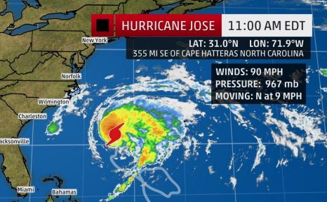
Hurricane Jose Expected to Bring High Surf to the Eastern Seaboard in the Upcoming Week; Tropical Storm Conditions Possible
Jose, a Category 1 hurricane in the western Atlantic, will continue to produce dangerous high surf and rip currents as it moves parallel to the Eastern Seaboard in the upcoming week. Rain and tropical storm-force winds could also brush portions of the East Coast. Jose is currently located around 355 miles southeast of the Cape Hatteras, North Carolina, and is moving north at near 10 mph. At this time, the majority of forecast guidance still shows Jose curling north, then northeast off of the U.S. East Coast. click here to read the story 13:09