


New York Bight – Interactive map shows where maritime industries, offshore wind could overlap
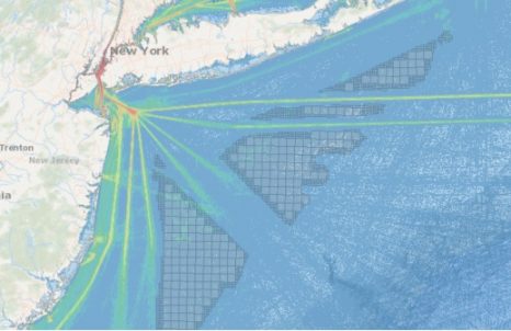
A new interactive map showing potential offshore wind energy areas in the New York Bight is now online to help mariners assess the potential impacts on their livelihoods, as federal officials gather information and comments this month. The Mid-Atlantic Regional Ocean Council (MARCO), an ocean planning partnership of state governments, posted the mapping tool Thursday. The base map shows the New York Bight “call area” where the federal Bureau of Ocean Energy Management is considering the possibility of offering future wind energy leases. (its bigger than Long Island) >click to read<


Leave a Reply