


Anticipating the winds of change: A baseline assessment of Northeastern US continental shelf surficial substrates
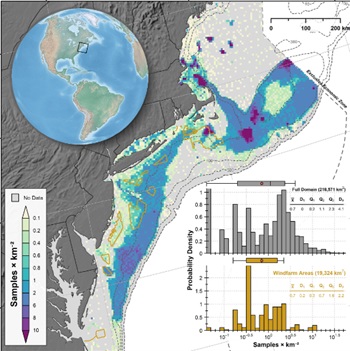 The introduction of thousands of wind turbines along the North American Atlantic continental shelf over the next decade will constitute the largest regional change in marine substrates since the retreat of the Laurentide Ice Sheet over 14,000 years ago. Here, two large data sets, SMAST drop camera survey (242,949 samples, 2003 to 2019) and the US Geological Survey databases (27,784 samples, 1966 to 2011), are combined to derive sea floor surficial substrate probability maps for the Northeastern US continental shelf from Virginia Beach to the Gulf of Maine to 300 m depth (218,571 km2). Geostatistical models were used to estimate the probability of five geologic and one biogenic substrate types being present at a 250 m resolution, and the proportional contribution of each substrate type to the seabed composition at a 500 m resolution. By providing the first synoptic maps depicting the probability of a particular substrate or combination of substrates occurring at any location on the Northeastern US continental shelf, including planned wind energy sites, we aim to (1) provide insights regarding how substrates in the areas selected for wind energy development compare with other locations, (2) motivate the development of a priori expectations for ecosystem changes to inform monitoring and research efforts going forward, and (3) to provide a baseline characterization of the Northeastern US continental shelf surficial substrates to support robust examination of the future changes observed in areas impacted by wind energy installations. more, >>CLICK TO READ<< 11:44


Leave a Reply