Tag Archives: National Hurricane Center
Hurricane Maria path: Category 2 storm may get uncomfortably close to East Coast before turning
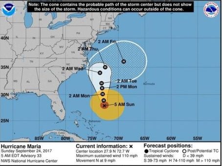
A weaker Hurricane Maria continued on a path northward off the U.S. East Coast on Sunday. The National Hurricane Center said Maria, a Category 2 hurricane with sustained winds of 110 mph, will continue to track northward parallel to the coast before making a turn away from land and to the east. It’s where and when that turn will happen that is problematic. Forecasters think the core of the hurricane will stay offshore, but it could come close enough that parts of the coast will feel some of its effects. For that reason, the hurricane center said tropical storm — or hurricane — watches may be issued for parts of the North Carolina or Mid-Atlantic coasts today. click here to read the story 10:48
The Latest – Hurricane Maria and Tropical Storm Jose Updates 800 PM AST
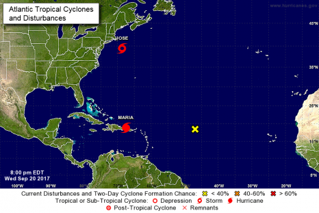
At 800 PM AST, the center of Tropical Storm Jose was located near latitude 39.4 North, longitude 68.6 West. Jose is moving toward the northeast near 8 mph (13 km/h), and this general motion with a decrease in forward speed is expected through tonight. A slow westward motion should begin by Thursday night. On the forecast track, the center of Jose is expected to meander off the coast of southern New England during the next few days. click here to read the advisory
At 800 PM AST (0000 UTC), the eye of Hurricane Maria was located by an Air Force reconnaissance aircraft near latitude 18.9 North, longitude 67.5 West. click here to read the advisory 20:23
National Hurricane Center – Hurricane Maria Public Advisory
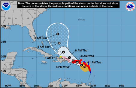
At 1100 AM AST, the eye of Hurricane Maria was located near latitude 16.3 North, longitude 63.1 West. Maria is moving toward the west-northwest near 10 mph (17 km/h), and this general motion is expected to continue through Wednesday night. On the forecast track, the eye of Maria will move over the northeastern Caribbean Sea today, and then pass near or over the Virgin Islands and Puerto Rico on Wednesday. Maximum sustained winds are near 160 mph (260 km/h) with higher gusts. Maria is a potentially catastrophic category 5 hurricane click here to read the update 11:23

National Hurricane Center – Hurricane Jose Public Advisory
Interests elsewhere along the U.S. east coast from North Carolina northward to New England should monitor the progress of Jose. At 800 AM EDT, the center of Hurricane Jose was located near latitude 33.5 North, longitude 71.2 West. Jose is moving toward the north near 9 mph (15 km/h) and this general motion is expected to continue through tonight. A turn toward the north-northeast is expected on Tuesday night. On the forecast track, the center of Jose is forecast to pass well offshore of the Outer Banks of North Carolina today, pass well east of the Delmarva peninsula tonight and Tuesday, and pass well to the east of the New Jersey coast on Wednesday. click here to read the notice 10:12

Tropical Storm Irma Public Advisory – 1100 AM EDT
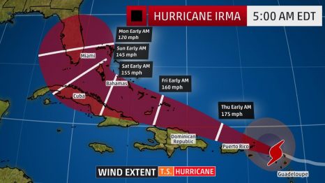
At 1100 AM EDT (1500 UTC), the center of Tropical Storm Irma was located near latitude 30.3 North, longitude 83.1 West. Irma is moving toward the north-northwest near 17 mph (28 km/h), and this motion is expected to continue through Tuesday. On the forecast track, the center of Irma will move into southwestern Georgia later today, and move into eastern Alabama Tuesday morning. Maximum sustained winds have decreased to near 65 mph (100 km/h) with higher gusts. Continued slow weakening is forecast, and Irma is likely to become a tropical depression on Tuesday. click here to read the update 11:10
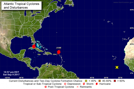
Hurricane Irma – Public Advisory – 1100 PM EDT Sat Sep 09 2017
At 1100 PM EDT (0300 UTC), the eye of Hurricane Irma was located near latitude 23.5 North, longitude 81.0 West. Irma is moving slowly northwestward away from the north coast of Cuba near 6 mph (9 km/h). A turn toward the north-northwest with an increase in forward speed is expected through late Monday. On the forecast track, the center of Irma is expected to cross the Lower Florida Keys Sunday morning and then move near or along the west coast of Florida Sunday afternoon through Monday morning. Irma should then move inland over the Florida panhandle and southwestern Georgia Monday afternoon. click here to read the update 23:05
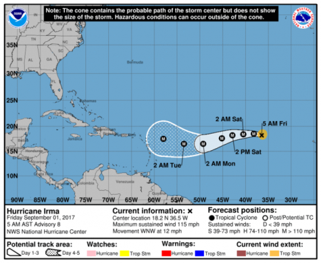
Hurricane Irma holding steady as Category 3 storm in Atlantic
Hurricane Irma was holding steady Friday morning (Sept. 1) as a Category 3 storm in the Atlantic, forecasters with the National Hurricane Center said. It’s unclear what impacts Irma might pose to land. Models are notoriously unreliable more than five days away, and Irma is not expected to near the Leeward Islands until sometime next week. The Leeward Islands are part of the eastern border of the Caribbean Sea. As of Friday morning, the storm was about 840 miles northwest of the Cabo Verde Islands and about 1,665 miles east of the Leeward Islands. It’s moving northwest at 12 mph. It’s expected to turn west again Friday night, followed by a turn to the west-southwest on Saturday. click here to read the advisory 08:29
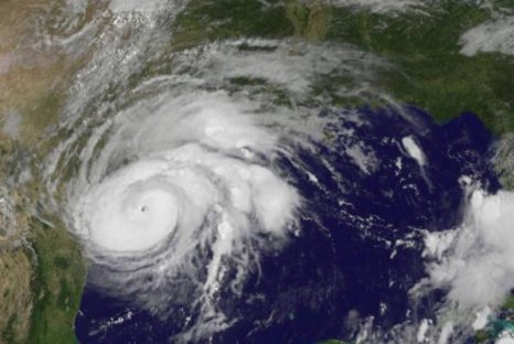
At Category 2, Hurricane Harvey fast approaching Texas
Hurricane Harvey intensified overnight and is expected to strike the Texas coast on Friday night or early Saturday, the National Hurricane Center said. The NHC said in Friday’s 10 a.m. advisory that Harvey has maximum sustained winds of 110 mph. The center of the storm is about 115 miles southeast of Corpus Christi, Texas, and 120 miles south-southeast of Port O’Connor. The NHC said in Friday’s 10 a.m. advisory that Harvey has maximum sustained winds of 110 mph. The center of the storm is about 115 miles southeast of Corpus Christi, Texas, and 120 miles south-southeast of Port O’Connor. click here to read the story 12:00
National Hurricane Center – Hurricane Harvey Public Advisory – click here to read the update
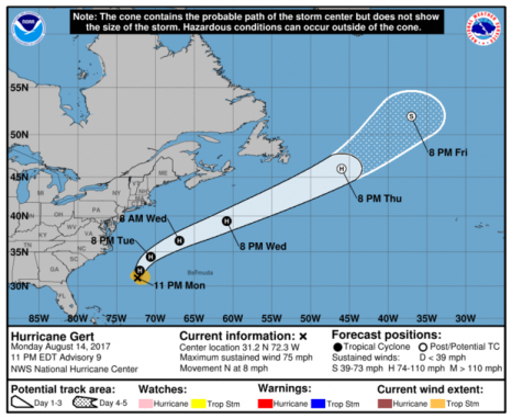
Hurricane Gert forms off East Coast, becoming second hurricane of the season
Gert became the second hurricane of the season Monday night (Aug. 14), National Hurricane Center forecasters said. Monday night, there were no coastal watches or warnings in effect, but forecasters warned that swells generated by Gert are expected to spread northward along the East Coast of the U.S., from North Carolina to Long Island, during the next couple of days. Late Monday, Gert churned about 445 miles west of Bermuda and was moving north at 8 mph, with forecasters calling for a turn toward the northeast and an increase in forward speed Tuesday night. click here to read the story 09:24
NOAA Quietly Deletes Apology For Sharing Anti-Trump Facebook Post
 A branch of the National Oceanic and Atmospheric Administration (NOAA) responsible for tracking hurricanes apologized Saturday for sharing a Facebook post critical of President Trump. The National Hurricane Center (NHC), rather surprisingly, deleted the apology from its Facebook page, which claimed a “hacked” personal account was responsible for sharing a post by Vermont Sen. Bernie Sanders. NHC’s Facebook page shared a Sanders post highlighting Saturday’s march in Washington, D.C., in protest to Trump taking office. NHC then quietly deleted off its Facebook account, but not before meteorologist Dr. Ryan Maue captured a screenshot. Read the rest here 10:59


