Tag Archives: National Hurricane Center
Rafael now a tropical storm: Any threat to Alabama?
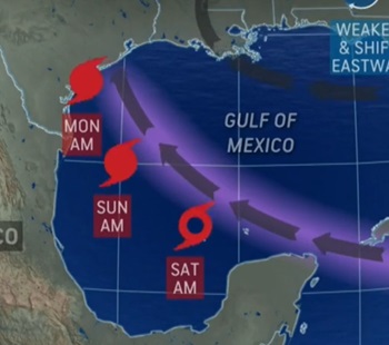
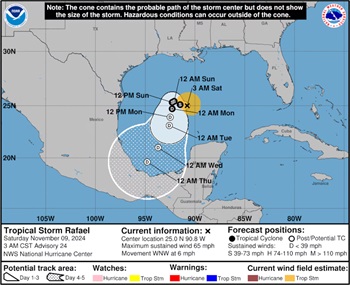 Rafael, a Category 3 hurricane just yesterday, has weakened rapidly to a tropical storm and had 65 mph winds on Saturday morning. The National Hurricane Center thinks the storm could drift southward over the Gulf of Mexico through the middle of next week. It could also continue to weaken and become a non-tropical system during that time. As of the last advisory, at 3 a.m. CST Saturday, Tropical Storm Rafael was located about 405 miles east of the mouth of the Rio Grande River and was moving to the west-northwest at 6 mph. more, >>CLICK TO READ<< 09:23
‘Life-threatening’ storm to remain major hurricane before Florida landfall, NHC says
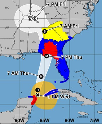
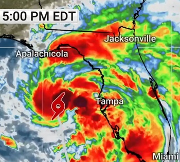
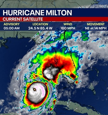 Hurricane Milton remained a Category 5 storm in the Gulf of Mexico through Tuesday night and into Wednesday morning. As of 5 a.m., Hurricane Milton was 300 miles from Tampa, Florida, with sustained winds of 160 mph. It is moving east-northeast at 14 mph. The minimum central pressure is 907 mb. “Milton is expected to remain an extremely dangerous major hurricane when it reaches the west-central coast of Florida”, the National Hurricane Center (NHC) said. In the 5 a.m. update, the National Hurricane Center said Hurricane Milton had sustained winds of 160 mph, making it a strong Category 5 storm on the Saffir-Simpson Hurricane Wind Scale. more, >>CLICK TO READ<< 08:12
Milton remains an ‘extremely dangerous’ hurricane after weakening to Cat 4, forecasters warn
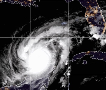 Hurricane Milton weakened slightly to a powerful Category 4 storm Tuesday morning while spiraling through the southern Gulf of Mexico and closer to Florida, according to the National Hurricane Center in Miami. Milton rapidly intensified from a tropical storm to a Category 5 hurricane on Monday, peaking with rare, sustained winds of 180 mph and becoming the strongest storm to ever form this late in the Atlantic season. Now, the hurricane is moving east-northeast at 12 mph with maximum sustained winds of 145 mph, NHC said in its latest update. However, forecasters warned that Milton’s change in strength doesn’t make it any less dangerous, adding that the storm will likely grow in size as it approaches Florida’s west coast and makes landfall Wednesday. more, >>CLICK TO READ<< 09:46
Hurricane Milton strengthens into Category 4 as Florida prepares for evacuations, storm surge
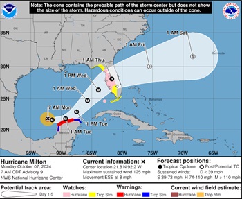 Milton rapidly strengthened into a Category 4 hurricane Monday on a path toward Florida population centers including Tampa and Orlando, threatening a dangerous storm surge in Tampa Bay and setting the stage for potential mass evacuations less than two weeks after a catastrophic Hurricane Helene swamped the coastline. The storm is expected to stay at about its current strength for the next couple of days, the National Hurricane Center in Miami said. Helene was also a Category 4 at landfall in northern Florida. Milton had maximum sustained winds of 150 mph (240 kph) over the southern Gulf of Mexico, the hurricane center said. Its center could make landfall Wednesday in the Tampa Bay area, and it could remain a hurricane as it moves across central Florida toward the Atlantic Ocean. more, >>CLICK TO READ<< 10:27
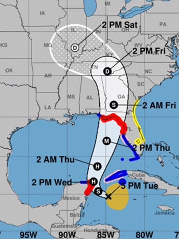
Tropical Storm Milton Path, Tracker As Potential Hurricane Nears Florida
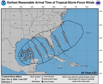 The latest forecast from the National Hurricane Center, released at 4 a.m. Central Time on Sunday, said that Milton will quickly intensify as it moves eastward and northeastward, making landfall in Florida as a Tropical Cyclone on Wednesday. As of Sunday morning, the center of the tropical storm has maximum wind speeds of 50 mph and is moving east at 5 mph. By Monday, winds are forecast to increase to between 74 and 110 miles per hour, and by Tuesday, have winds in excess of 110 miles per hour. The forecast path will cross Florida east to west, centering on Tampa Bay, with the edge of the storm crossing southeastern Alabama, southern Georgia, southeastern South Carolina, and Alabama, southern Georgia, southeastern South Carolina more, >>CLICK TO READ<< 09:32
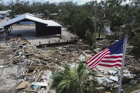
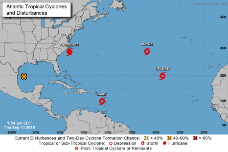
Southeast US devastated by remnants of Hurricane Helene
The remnants of Hurricane Helene have caused devastation across the Southeastern United States, leaving dozens dead, many stranded, and millions without power. Helene, the strongest hurricane recorded to hit Florida’s Big Bend region, has since weakened to a post-tropical cyclone but is still bringing catastrophic flooding, powerful winds, and unthinkable damage up the east coast from Florida to Virginia. As of Sunday, at least 60 people were reported dead. Landslides and flooding as a result of the tropical storm have left entire towns, families, even hospitals cut off and stranded needing rescue. Many across five states were left unprepared for the life-changing destruction as Helene intensified quickly during the week. Hurricane researchers estimated that unusually warm ocean temperatures combined with swift changes in wind heights may be the reason for the intense development. Video, Links, more, >>CLICK TO READ<< 13:04
Dozens dead and millions without power after Helene’s deadly march across southeastern US
 Hurricane Helene caused dozens of deaths and billions of dollars of destruction across a wide swath of the southeastern U.S. as it raced through, and more than 3 million customers went into the weekend without any power and for some a continued threat of floods. Helene blew ashore in Florida’s Big Bend region as a Category 4 hurricane late Thursday packing winds of 140 mph (225 kph) and then quickly moved through Georgia, the Carolinas and Tennessee, uprooting trees, splintering homes and sending creeks and rivers over their banks and straining dams. The storm, now a post-tropical cyclone, was expected to hover over the Tennessee Valley on Saturday and Sunday, the National Hurricane Center said. Several flood and flash flood warnings remained in effect in parts of the southern and central Appalachians, while high wind warnings also covered parts of Tennessee and Ohio. more, >>CLICK TO READ<< 06:54
Hurricane Helene will make catastrophic Florida landfall; Tallahassee is near direct path
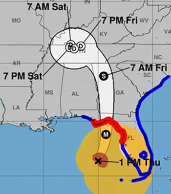 Hurricane Helene’s wide and destructive wind field was moving along the Gulf Coast of Florida southwest of Tampa on Thursday morning and is expected to rapidly intensify on a direct path for the state’s Big Bend region, where it could pose “a nightmare surge scenario for Apalachee Bay,” according to the National Weather Service. The state’s capital, Tallahassee, is just east of the direct path of Helene, which reached Category 2 strength Thursday and is expected to grow into a major Category 3 storm before making landfall late Thursday or early Friday morning. Forecasters said Helene will intensify further than previously forecast, predicting 130 mph winds before landfall. “This forecast, if realized, is a nightmare surge scenario for Apalachee Bay,” the National Weather Service office said. “Please, please, please take any evacuation orders seriously!” Photos, more, >>CLICK TO READ<< 14:29
Live updates: Helene strengthening, now forecast to hit Florida as Category 4 hurricane
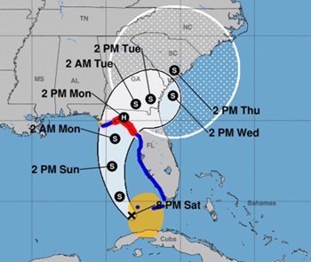
 Helene became a hurricane late Wednesday morning and is rapidly strengthening. The storm is forecast to barrel into Florida’s Gulf Coast as a monster Category 4 hurricane with up to 132-mph winds Thursday, according to the National Hurricane Center. Hurricane Helene is expected to intensify and grow rapidly over the Gulf of Mexico before slamming into Florida’s Gulf Coast. According to AccuWeather forecasters, the highest landfall probability is “somewhere along the eastern part of the Florida Panhandle–perhaps in the Big Bend area–late Thursday evening.” However, an earlier landfall over the Florida Peninsula is possible if Helene tracks farther to the southeast, forecasters said. There is a danger of life-threatening storm surge along the entire west coast of Florida and Florida’s Big Bend, the NHC reported. The highest inundation levels and potentially catastrophic hurricane-force winds are expected along the Big Bend coast. Video, lots of images, more, >>CLICK TO READ<< 19:06 Stay safe!
‘Potentially catastrophic’: Helene forecast to hit Big Bend with 115 mph winds
 Helene, which organized into a tropical storm on Tuesday, is forecast to rapidly intensify into a powerful and massive before barreling into the Big Bend likely overnight Thursday, bringing “potentially catastrophic” wind and storm surge. An alert jolted with 115 mph winds residents’ phones at 5 p.m. as forecasters issued hurricane warnings for Dixie, Franklin, Gadsden, Jefferson, Lafayette, Liberty, Leon, Madison, Taylor and Wakulla counties. A storm surge warning for what could be as much as 15-feet of inundation was also in effect for the Apalachee Bay coast. The National Hurricane Center’s tightening cone of uncertainty continued to show landfall anywhere from Panama City to Cedar Key. The center line, which forecasters caution people not to focus on, remained over Tallahassee in the 5 p.m. forecast. Helene was forecast to strengthen into a hurricane by Wednesday morning and a major hurricane, with winds of 110 mph or more, by Thursday morning. more, >>CLICK TO READ<< 19:27
UPDATE: Tropical Storm Debby to Bring Major Flooding to Southeast After Florida Landfall
 Tropical Storm Debby could bring historically heavy rainfall, gusty winds and a few tornadoes, from north Florida to coastal South Carolina after making landfall in Florida’s Big Bend region Monday. Flash flooding is the number one concern with Debby. NOAA has issued their highest level of flood outlook for both Monday and Tuesday, shown in pink on the maps below. These areas will likely experience damaging flooding and could experience life-threatening flooding. Debby will also bring gusty winds, coastal flooding and a few tornadoes across the Florida Peninsula Sunday and then along the Southeast coast early in the coming week, where it could slow down or even stall, prolonging impacts. Here’s where watches and warnings are in effect: A hurricane warning is in effect for the Florida Big Bend region from the Suwannee River to Indian Pass. more, >>CLICK TO READ<< 19:56
Tropical Storm Debby timeline: When could it become hurricane, make landfall?
 Tropical Storm Debby officially formed Saturday afternoon, making it the fourth named storm of the 2024 Atlantic hurricane season, according to the National Hurricane Center. Forecasters believe Tropical Storm Debby could be ‘at or near hurricane’ strength as it approaches the Florida coast before landfall, according to the 5 p.m. advisory. A timeline has been established for when the eye of what is now known as Tropical Storm Debby could impact Florida over the weekend and into early next week. On Saturday, the NHC issued a hurricane watch and warning for portions of Florida’s Gulf Coast. more, >>CLICK TO READ<< 07:32
Hurricane forecasters warn Beryl will strengthen before slamming into Texas
 Tropical Storm Beryl marched toward the Texas coast Sunday morning as forecasters warned the storm will regain hurricane strength and slam ashore early Monday. However, Beryl’s impacts – such as strong winds, heavy rain, and rough seas – will begin in South Texas well before landfall, the National Hurricane Center warned. “Winds are first expected to reach tropical storm strength by late today (Sunday), making outdoor preparations difficult or dangerous,” the Center said. The storm made landfall on Mexico’s Yucatan Peninsula Friday morning, after it plowed through the Caribbean and Jamaica earlier this week, killing at least 11 people. At 8:00 a.m. EDT, the center of Beryl was located about 220 miles southeast of Corpus Christi in the Gulf of Mexico, traveling northwest at 12 mph. It was expected to continue moving northwest throughout the day Sunday, then north-northwest by Sunday night. Video, photos, more, >>CLICK TO READ<< 11:37
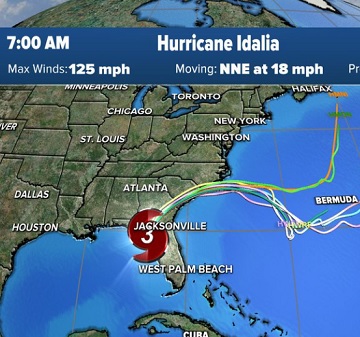
Hurricane Idalia at Category 3 strength ahead of Florida landfall
Hurricane Idalia strengthened into a powerful Category 4 storm Wednesday morning, then weakened slightly to a Category 3, ahead of landfall in Florida’s Big Bend region. According to the 7 a.m. advisory from the National Hurricane Center, Idalia has maximum sustained winds of 125 miles per hour, and catastrophic storm surge and destructive winds are nearing the Big Bend. WPTV First Alert Weather meteorologist Jennifer Correa said landfall is expected around 8 a.m. Wednesday, and Idalia’s center should stay east of Tallahassee. After making landfall on Wednesday, Idalia will weaken to a Category 2 hurricane over southeastern Georgia, and then a tropical storm by late Wednesday. >>click to read<< 08:04
Nicole Expected to Become Hurricane Wednesday Before Impacting Florida’s East Coast
Tropical Storm Nicole is expected to become a Category 1 hurricane Wednesday as it moves toward the east coast of Florida, forecasters said. Nicole had maximum sustained winds of 70 miles per hour and was moving west-southwest at 13 mph about 270 miles east of West Palm Beach, according to the latest advisory from the National Hurricane Center in Miami. Nicole is forecast to be at hurricane intensity by Wednesday or Wednesday night while it is moving near or over the northwestern Bahamas, the hurricane center said. >click to read< 06:37
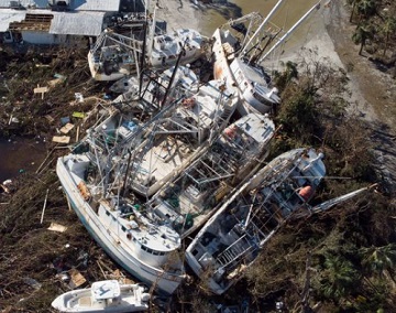
Florida, Carolinas count the cost of Hurricane Ian
Florida, North and South Carolina faced a massive clean-up on Saturday from the destruction wrought by Hurricane Ian, after one of the most powerful storms ever to hit the U.S. mainland caused tens of billions of dollars in damage and killed more than 20 people. Ian, now a post-tropical cyclone, was weakening but still forecast to bring treacherous conditions to parts of the Carolinas, Virginia and West Virginia into Saturday morning, according to the National Hurricane Center. “Major to record river flooding will continue across central Florida through next week. Limited flash, urban and small stream flooding is possible across the central Appalachians and the southern Mid-Atlantic this weekend, with minor river flooding expected over the coastal Carolinas,” it said. >click to read< 08:40
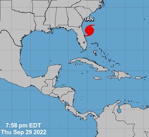
Hurricane Ian Taking Aim at the Carolinas and Georgia – Public Advisory – 800 PM EDT
At 800 PM EDT (0000 UTC), the center of Hurricane Ian was located by an Air Force Hurricane Hunter aircraft near latitude 29.7 North, longitude 79.4 West. Ian is moving toward the north-northeast near 10 mph (17 km/h). A turn toward the north is expected tonight, followed by a turn toward the north-northwest with an increase in forward speed Friday night. On the forecast track, Ian will approach the coast of South Carolina on Friday. The center will move farther inland across the Carolinas Friday night and Saturday. Maximum sustained winds are near 75 mph (120 km/h) with higher gusts. Ian could slightly strengthen before landfall tomorrow and is forecast to rapidly weaken over the southeastern United States late Friday into Saturday. >click to read< Graphics, >click here< 20:15

Hurricane Ian makes landfall, causes ‘catastrophic storm surge, winds and flooding’ in southwest Florida
Hurricane Ian weakened slightly again late Wednesday afternoon but remained a dangerous Category 4 storm with top winds of 140 mph. The storm. which previously produced top winds of 155 mph, is forecast to weaken further as it travels up the Florida peninsula, according to a 5 p.m. update from the National Hurricane Center. In 12 hours, the storm’s winds are expected to fall to 85 mph, making the storm a Category 1 hurricane. “It will still pack a formidable punch as it moves across the state of Florida along the I-4 corridor in the next couple of days,” Video, photos, >click to read< 17:57
U.S. Coast Guard urges preparedness for Tropical Storm Henri
Boston — The Coast Guard urges all mariners to prepare for Tropical Storm Henri before its predicted Sunday landfall. The National Oceanic and Atmospheric Administration predicts Henri to have wind speeds equal to or exceeding 39 mph. Storm Surge and Hurricane watches are in effect for portions of the United Stated –>click to read<-The Coast Guard is reminding the public of these important safety messages: Port conditions change based on weather forecasts, and current port conditions can be viewed on the following Coast Guard homeport webpage: >click to read>14:15<
Tropical Storm Warning up along northern Gulf Coast with Claudette forming today
At 10 a.m. Friday, the National Hurricane Center said Potential Tropical Cyclone 3 was centered 220 miles south of Morgan City, Louisiana and moving north at 14 mph. It had sustained winds of 35 mph. It is expected to strengthen into Tropical Storm Claudette by afternoon and reach the northern Gulf Coast by Saturday morning. Winter dry air is still mixing down deep into the tropics. Yes, it is not cold air, but it is dry air. This almost always leads to asymmetrical tropical systems. The “wet” side is generally east of the storm track and it is in this region, where over the next 3-5 days we will see the wettest and stormiest, along with the highest winds and highest storm surge (if any, this is a weak system). >click to read< 11:41
Between June 18 and 21, 1959, an Atlantic hurricane caused one of New Brunswick’s worst fishing-related disasters. – The incident, called the 1959 Escuminac disaster, killed 35 people and caused US$2.5 million worth of damage. On June 18, the storm developed in the Gulf of Mexico. >click to read< – 16:41, 6/20/2021
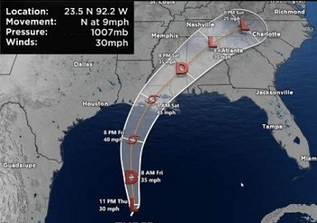
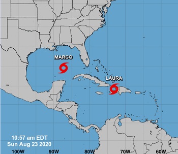
Marco now a Tropical Depression, Laura expected to Strengthen into a Hurricane today
Marco – Maximum sustained winds are near 30 mph (45 km/h) with higher gusts. Additional weakening is expected,,, This is the last public advisory issued by the National Hurricane Center on Marco. >click to read< Tropical Storm Laura – On the forecast track, the center of Laura will move away from Cuba and over the southeastern Gulf of Mexico this morning. Laura is then forecast to move over the central and northwestern Gulf of Mexico tonight and Wednesday, approach the Upper Texas and Southwest Louisiana coasts on Wednesday night and move inland near those area on Thursday. >click to read< 08:01
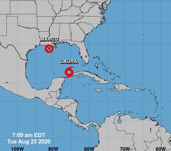
UPDATED: Hurricane Marco and Tropical Storm Laura Advisories
At 800 AM EDT (1200 UTC), the center of Tropical Storm Laura was located near latitude 20.9 North, longitude 79.7 West. Laura is moving toward the west-northwest near 21 mph (33 km/h), and this general motion with some decrease in forward speed is expected over the next couple of days. >click to read< 700 AM CDT (1200 UTC), the center of Tropical Storm Marco was located near latitude 28.1 North, longitude 88.4 West. Marco is moving toward the northwest near 10 mph (17 km/h). Marco is forecast to approach the coast of Louisiana this afternoon, and then turn westward and move very close to the coast of Louisiana through Tuesday night. >click to read< 08:15
Tropical Storm Media Advisories for Laura and Marco
Marco expected to become a Hurricane today as it enters the Central Gulf Of Mexico, Life-Threatening storm surge and Hurricane Force Winds expected along portions of the Gulf Coast,, >click to read< Tropical Storm Laura – Heavy Rainfall and life threatening Flash Flooding over Portions of the Dominican Republic and Haiti,, >click to read< 12:10
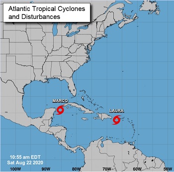
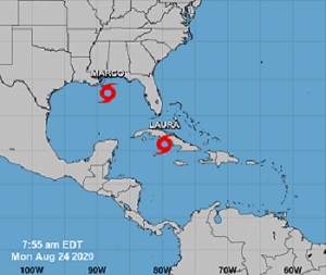
National Hurricane Center Advisories for the Atlantic- Tropical Storm Laura, and Tropical Storm Marco
Tropical Storm Laura Public Advisory – Tropical Storm Laura Advisory Number 11, NWS National Hurricane Center, 1100 AM AST Sat Aug 22 2020 >click to read<Tropical Storm Marco Advisory Number 9, NWS National Hurricane Center, Miami FL, 1000 AM CDT Sat Aug 22 2020 …MARCO STRENGTHENING QUICKLY… FORECAST TO BECOME A HURRICANE LATER TODAY… >click to read< 12:37
![]() The Coast Guard Captain of the Port (COTP) set port condition X-Ray, – for the ports of Tampa to Fort Myers at 12:00 p.m. Saturday, due to the expectation of Tropical Storm Laura generating sustained gale force winds within 48 hours >click to read<
The Coast Guard Captain of the Port (COTP) set port condition X-Ray, – for the ports of Tampa to Fort Myers at 12:00 p.m. Saturday, due to the expectation of Tropical Storm Laura generating sustained gale force winds within 48 hours >click to read<

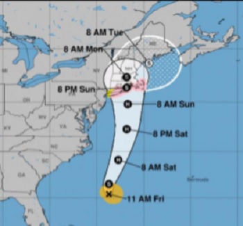
Hurricane Dorian picks up speed as it moves away from the North Carolina coast
Hurricane Dorian was speeding up Friday afternoon as it moved farther away from the North Carolina coast,,,The storm sped up to 24 mph as it continued moving northeast away from the mid-Atlantic states toward Nova Scotia, which is expected to feel hurricane-force winds this weekend,,,The center of the eye passed the Outer Banks off the North Carolina coast at 8:35 a.m >click to read< 19:08
NWS National Hurricane Center – Hurricane Florence Advisory Update 200 PM EDT
Hurricane Florence Intermediate Advisory – NWS National Hurricane Center Miami FL LOCATION…33.6N 76.0W ABOUT 110 MI…180 KM ESE OF WILMINGTON NORTH CAROLINA, ABOUT 165 MI…270 KM E OF MYRTLE BEACH SOUTH CAROLINA, MAXIMUM SUSTAINED WINDS…105 MPH…165 KM/H, PRESENT MOVEMENT…NW OR 315 DEGREES AT 10 MPH…17 KM/H MINIMUM CENTRAL PRESSURE…955 MB…28.20 INCHES >click to read<14:13
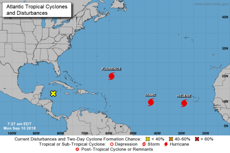
National Hurricane Center: Hurricane Florence Public Advisory
At 500 AM AST (0900 UTC), the center of Hurricane Florence was located near latitude 24.9 North, longitude 58.9 West. Florence is moving toward the west-northwest near 9 mph (15 km/h). A west-northwestward motion with an increase in forward speed is expected during the next couple of days. A turn toward the northwest is forecast to occur Wednesday night or Thursday. On the
forecast track, the center of Florence will move over the southwestern Atlantic Ocean between Bermuda and the Bahamas Tuesday and Wednesday, and approach the southeastern coast of the United States on Thursday. >click to read<09:17
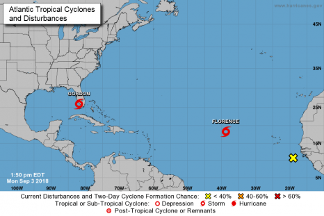
Tropical Storm Gordon Public Advisory: Storm Surge Warning, Hurricane Watch is in effect
At 200 PM EDT (1800 UTC), the center of Tropical Storm Gordon was located near latitude 25.8 North, longitude 81.9 West. Gordon is moving toward the west-northwest near 16 mph (26 km/h and a west- northwestward to northwestward motion is expected over the next 72 hours. On the forecast track, the center of Gordon will move farther away from the southwestern coast of Florida this afternoon and move across the eastern Gulf of Mexico tonight and Tuesday. The center of Gordon will approach the coast within the warning area along the central Gulf Coast by late Tuesday or Tuesday night, and move inland over the lower Mississippi Valley on Wednesday. >click to read<14:48
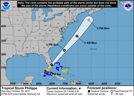
Tropical Storm Philippe heads toward Florida Keys
Tropical Storm Philippe, which formed Saturday afternoon (Oct. 28) off the coast of Cuba, was closing in on the Florida Keys hours later and expected to cross the southern tip of the state overnight. According to the National Hurricane Center, Philippe was still a weak tropical storm as of 8 p.m. Central time with maximum sustained winds of 40 mph. It was was 75 miles southwest of Key West and moving north at 28 mph. The storm is expected to make a turn to the northeast overnight, taking it into the northwest Bahamas by Sunday morning. click here to read the story 21:36

Tropical storm Nate weakens but rain, floods to continue
A fast-moving storm called Nate brought flooding and power outages to the U.S. Gulf Coast early Sunday after it sloshed ashore outside Biloxi, Mississippi — the first hurricane to make landfall in that state since Katrina devastated the region 12 years ago. The storm hit Mississippi as a Category 1 hurricane with maximum sustained winds near 85 mph (140 kph) but weakened later to a tropical storm as it moved inland, the U.S. National Hurricane Center in Miami said. More than 100,000 residents in Mississippi and Alabama were without power following the arrival of Nate, but no deaths or injuries were reported early Sunday. click here to read the story 09:53