Tropical Storm Warning up along northern Gulf Coast with Claudette forming today
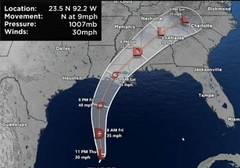
At 10 a.m. Friday, the National Hurricane Center said Potential Tropical Cyclone 3 was centered 220 miles south of Morgan City, Louisiana and moving north at 14 mph. It had sustained winds of 35 mph. It is expected to strengthen into Tropical Storm Claudette by afternoon and reach the northern Gulf Coast by Saturday morning. Winter dry air is still mixing down deep into the tropics. Yes, it is not cold air, but it is dry air. This almost always leads to asymmetrical tropical systems. The “wet” side is generally east of the storm track and it is in this region, where over the next 3-5 days we will see the wettest and stormiest, along with the highest winds and highest storm surge (if any, this is a weak system). >click to read< 11:41
Between June 18 and 21, 1959, an Atlantic hurricane caused one of New Brunswick’s worst fishing-related disasters. – The incident, called the 1959 Escuminac disaster, killed 35 people and caused US$2.5 million worth of damage. On June 18, the storm developed in the Gulf of Mexico. >click to read< – 16:41, 6/20/2021














Leave a Reply