


Exactly where do Maine lobstermen fish?! The government wants to know
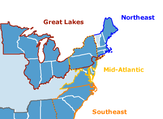 It is the state’s largest fishery, bringing in more than $500 million a year and employing tens of thousands of people up and down the supply chain, but there is no map that shows exactly where Maine’s lobstermen trap their catch. Most of them fish within 3 miles of the coast, and thus do not fill out detailed federal catch reports or have onboard satellite tracking systems that lend themselves to detailed maps of valuable fishing territories. That suits many lobstermen just fine, because they say their territory changes from year to year and they don’t like the notion of the government tracking where they fish. But that attitude makes life difficult for regulatory agencies responsible for permitting non-fishing activities in the Gulf of Maine, such as wind farms or mining operations. The lack of detailed, up-to-date maps of lobster fishing grounds is obvious when reviewing the hundreds of maps collected by the Northeast Regional Planning Body, the federal planning body that is overseeing the nation’s regional ocean planning from the Gulf of Maine to Long Island Sound. The council is building a trove of online data,,, Read the rest here 12:35


Leave a Reply