Tag Archives: National Weather Service

Rhode Island’s ‘Squid Squad’ targeted in DOGE purge of NOAA
The head of squid research at the National Oceanic and Atmospheric Administration’s (NOAA) Narragansett Bay facility is among the hundreds of agency employees nationwide who are no longer on the job, according to one of NOAA’s former administrators. Former National Marine Fisheries Service Administrator Janet Coit said Monday that about 20 employees from NOAA’s Rhode Island office and the Woods Hole Oceanographic Institute in Massachusetts were recently dismissed by Elon Musk’s Department of Government Efficiency (DOGE). Coit shared the revelation during a roundtable discussion hosted by U.S. Rep. Seth Magaziner (D-R.I.) at Save the Bay’s headquarters near the Port of Providence. more, >>CLICK TO READ<< 06:56
NOAA firings hit crucial Alaska weather service, fishery research
 Alaskans were among the hundreds of National Oceanic and Atmospheric Administration employees who began receiving firing notices this week, a blow to an agency that provides everything from weather forecasts to fisheries management to cutting-edge climate science in Alaska. The cuts — part of a broader effort by the administration of President Donald Trump to drastically slash the federal workforce — came after other agencies, including the National Park Service, had abruptly fired probationary workers in recent weeks. Nationally, more than 800 people across NOAA, an organization of 13,000 staff members, were fired, the New York Times reported Thursday. In Alaska, it was not immediately clear how many had lost their jobs, but they included NOAA employees working on fishery research and weather monitoring, among other functions. Photos, more, >>CLICK TO READ<< 10:21
DOGE Email Throws Federal Agencies Into Chaos and Confusion
 On Saturday, employees throughout the federal government received an email from the Office of Personnel Management (OPM), demanding a reply with “approx. 5 bullets of what you accomplished last week.” On X, Elon Musk posted that failure to respond, “will be taken as a resignation.” The result? Confusion, chaos, and resentment among a federal workforce that increasingly feels under attack. “So f-ing dumb,” says one air traffic controller who received the email and was granted anonymity for fear of retribution. Leaders of many agencies appear to have been caught off guard. At the National Oceanic and Atmospheric Administration (NOAA), which houses the National Weather Service, some managers initially cautioned against replying to the email in case it was a phishing attempt. Another NOAA employee says they were cautioned not to log onto their work email after receiving it. more, >>CLICK TO READ<< 12:27

NOAA set to slash jobs ‘imminently’
Mass firings are set to hit the National Oceanic and Atmospheric Administration (NOAA) “imminently,” a source with knowledge told The Hill. The person, who asked to speak anonymously due to fear of reprisals, said that the agency had not yet been subjected to the steep cuts announced elsewhere due to the then-pending confirmation of Commerce Secretary Howard Lutnick. The Commerce Department oversees NOAA and the National Weather Service. Many of the federal cuts thus far have targeted probationary workers, which includes recent hires but also those who have been recently promoted. more, >>CLICK TO READ<< 12:34
Hurricane DOGE Sweeps into the National Oceanic and Atmospheric Administration
![]() NOAA (National Oceanic and Atmospheric Administration) has been actively involved in Diversity, Equity, and Inclusion (DEI) initiatives, embracing them tightly during the last 4 years. This is the federal agency responsible for e federal agency for forecasting the weather, researching and analyzing climate data. and tracking storms. So, it is a little perplexing that the staff was distracted by social justice initiatives, rather than the meteorological science American expected them to focus on. Now the Department of Government Efficiency (DOGE), led by Elon Musk, has gained access to NOAA’s IT systems and is currently reviewing the agency’s DEI program after having been initially denied entry. Links, more, >>CLICK TO READ<< 08:17
NOAA (National Oceanic and Atmospheric Administration) has been actively involved in Diversity, Equity, and Inclusion (DEI) initiatives, embracing them tightly during the last 4 years. This is the federal agency responsible for e federal agency for forecasting the weather, researching and analyzing climate data. and tracking storms. So, it is a little perplexing that the staff was distracted by social justice initiatives, rather than the meteorological science American expected them to focus on. Now the Department of Government Efficiency (DOGE), led by Elon Musk, has gained access to NOAA’s IT systems and is currently reviewing the agency’s DEI program after having been initially denied entry. Links, more, >>CLICK TO READ<< 08:17
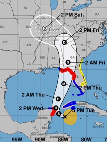
Hurricane Helene will make catastrophic Florida landfall; Tallahassee is near direct path
 Hurricane Helene’s wide and destructive wind field was moving along the Gulf Coast of Florida southwest of Tampa on Thursday morning and is expected to rapidly intensify on a direct path for the state’s Big Bend region, where it could pose “a nightmare surge scenario for Apalachee Bay,” according to the National Weather Service. The state’s capital, Tallahassee, is just east of the direct path of Helene, which reached Category 2 strength Thursday and is expected to grow into a major Category 3 storm before making landfall late Thursday or early Friday morning. Forecasters said Helene will intensify further than previously forecast, predicting 130 mph winds before landfall. “This forecast, if realized, is a nightmare surge scenario for Apalachee Bay,” the National Weather Service office said. “Please, please, please take any evacuation orders seriously!” Photos, more, >>CLICK TO READ<< 14:29
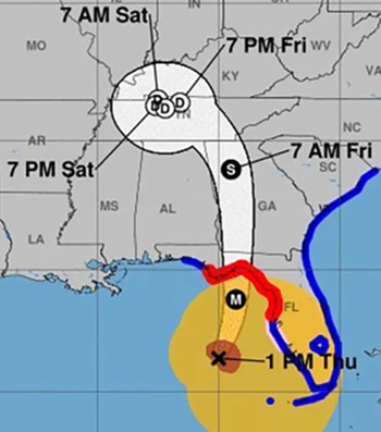
‘Potentially catastrophic’: Helene forecast to hit Big Bend with 115 mph winds
 Helene, which organized into a tropical storm on Tuesday, is forecast to rapidly intensify into a powerful and massive before barreling into the Big Bend likely overnight Thursday, bringing “potentially catastrophic” wind and storm surge. An alert jolted with 115 mph winds residents’ phones at 5 p.m. as forecasters issued hurricane warnings for Dixie, Franklin, Gadsden, Jefferson, Lafayette, Liberty, Leon, Madison, Taylor and Wakulla counties. A storm surge warning for what could be as much as 15-feet of inundation was also in effect for the Apalachee Bay coast. The National Hurricane Center’s tightening cone of uncertainty continued to show landfall anywhere from Panama City to Cedar Key. The center line, which forecasters caution people not to focus on, remained over Tallahassee in the 5 p.m. forecast. Helene was forecast to strengthen into a hurricane by Wednesday morning and a major hurricane, with winds of 110 mph or more, by Thursday morning. more, >>CLICK TO READ<< 19:27
Inoperable weather buoys at mouth of the Columbia River stir concern
 On the first day of commercial Dungeness crab season, Kelsey Cutting began his morning the way most crab fishermen do: checking the weather. Like many commercial fishermen, Cutting relies on data from weather buoys at the mouth of the Columbia River to guide his decisions. But as he’s learned, not all weather buoys are created equal — and when one goes out, there can be serious consequences. The National Oceanic and Atmospheric Administration operates two buoys at the mouth of the river that track real-time data on barometric pressure, wind direction, speed and gust, air and sea temperature, humidity and waves, which help inform National Weather Service forecasts. The buoys have been out of operation since late last year. more, >>click to read<< 15:18
Powerful winter storm pummels the Golden State
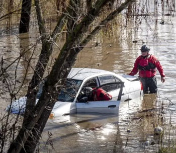 Millions of Southern Californians are waking up to a powerful storm that’s expected to linger over the region through Monday, bringing risks of dangerous flooding, road closures, power outages and other hazards. The slow-moving atmospheric river made its way into Southern California on Sunday afternoon after dousing the Bay Area and Central Coast earlier in the weekend. National Weather Service officials issued flash flood warnings for large swaths of San Luis Obispo, Santa Barbara, Ventura and Los Angeles counties. The warnings were set to expire at 12 a.m. Monday but could be extended. It wasn’t just SoCal; the atmospheric river brought heavy rain and strong winds across the Bay Area and Central Coast earlier Sunday. more, >>click to read<< 09:40
Idalia emerges as threat to Florida with potential as category 3 hurricane
![]() The National Weather Service warned on Monday that Tropical Storm Idalia is expected to intensify into a major category 3 hurricane by Wednesday. As of 8 a.m. E.D.T. on Monday, Idalia was about 90 miles south of the western tip of Cuba and was expected to become a hurricane as it approached the coast of Cuba. Idalia had sustained maximum winds of 65 mph and was moving north. While the track of the hurricane remained the same, the expected intensity has increased. Florida’s Division of Emergency Management on Monday morning said its state emergency operations center was activated to a “level 1″ in response to Idalia. >click to read< 09:50
The National Weather Service warned on Monday that Tropical Storm Idalia is expected to intensify into a major category 3 hurricane by Wednesday. As of 8 a.m. E.D.T. on Monday, Idalia was about 90 miles south of the western tip of Cuba and was expected to become a hurricane as it approached the coast of Cuba. Idalia had sustained maximum winds of 65 mph and was moving north. While the track of the hurricane remained the same, the expected intensity has increased. Florida’s Division of Emergency Management on Monday morning said its state emergency operations center was activated to a “level 1″ in response to Idalia. >click to read< 09:50
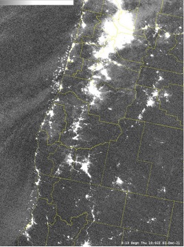
Images of Oregon Coast Crabbers Aglow from Outerspace!
As commercial crabbing on the Oregon coast opens on time for the first time in several years, the state’s crabbing fleet makes an impression in outer space. A satellite from the National Weather Service (NWS) managed to capture an enormous pattern of glowing dots skirting the edge of the state’s shoreline, turning out to be a spectacular shot of Oregon crabbing boats from several miles up just beyond our atmosphere. The NWS sent out the photo this week after checking its satellite feed, finding not just the usual, unmistakable glow of city lights in the valley towns, but a bundle of dots just offshore. >click to read< 11:31

‘Everything is Gone’ New Jersey’s Largest Dairy Devastated by Hurricane Ida
The National Weather Service has confirmed five tornadoes touched down in New Jersey and eastern Pennsylvania Wednesday evening during the fierce thunderstorms that were triggered by the leftovers of Hurricane Ida. The Eachus family owns and operates Wellacrest Farms, home to 1,400 Holsteins cows. The family says they are still trying to process what quickly unfolded and the damage left behind. >click to read< This isn’t just a job. It’s our lives. Tornado ravages New Jersey’s largest dairy farm – The blue skies and chalky clouds above Wellacrest Farms resemble illustrations in a children’s book. But the destruction on the ground evokes images more akin to a horror film. “It’s hard to believe that, for about one minute of time, so much destruction could happen,” said Eric Eachus, a third-generation co-owner of the farm his grandparents built in 1943. >click to read< 08:45
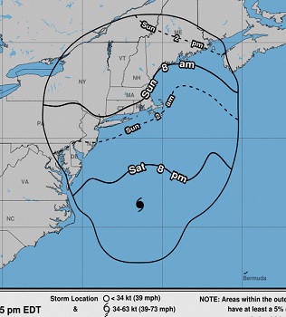
,,,Hurricane Henri Moving Faster To The North-East,,,
At 500 PM EDT, the center of Hurricane Henri was located near latitude 36.3 North, longitude 71.4 West. Henri is moving toward the north-northeast near 18 mph (30 km/h) and this motion is expected to continue through tonight. A decrease in forward speed and a turn toward the north-northwest is expected on Sunday. On the forecast track, Henri is expected to make landfall on Long Island or in southern New England on Sunday. >click to read< – National Weather Center, >click here< 17:10
Tropical Storm Elsa Public Advisory – 800 AM EDT
The center of Tropical Storm Elsa was located near latitude 24.5 North, longitude 82.6 West. Elsa is moving toward the north-northwest near 12 mph (19 km/h) and this general motion is expected to continue today, followed by a turn toward the north by tonight. A north-northeastward motion is expected on Wednesday. On the forecast track, Elsa will continue to pass near the Florida Keys this morning, and move near or over portions of the west coast of Florida later today through tonight. On Wednesday morning, Elsa is forecast to make landfall along the north Florida Gulf coast and then move northeastward across the southeastern United States through Thursday. >click to read< 08:25

F/V Scandies Rose: Inaccurate Stability Instructions, Ice Accumulation Led to Fatal Sinking
NTSB issues 7 Safety Recommendations from its investigation into the F/V Scandies Rose sinking. The 130-foot crab fishing vessel capsized and sank on December 31, 2019, The investigation found that although the crew loaded the Scandies Rose per the stability instructions on board, the instructions were inaccurate and, as a result, the vessel did not meet regulatory stability criteria and was more susceptible to capsizing. The NTSB made seven recommendations, including four to the Coast Guard, one to the North Pacific Fishing Vessel Owners’ Association, one to the National Oceanic and Atmospheric Administration and one to the National Weather Service. The agency also reiterated two safety recommendations previously issued to the U.S. Coast Guard. >click to read<,– to review all related articles, >click here<10:32

F/V Scandies Rose: Survivor Jon Lawler’s Wrenching Testimony, Experts note serious flaws in a USCG regulation
The architects who testified were not involved with the development of the stability booklet for the Scandies Rose, a Washington managed boat which went down around 10 p.m. in the Gulf of Alaska during a storm that generated National Weather Service warnings of heavy freezing spray. Also Wednesday, Jon Lawler, one of the two survivors of the seven-person crew, offered wrenching testimony of the final minutes before the boat went under. After donning a survival suit, he exited the wheelhouse amid what he described as sheer panic as the boat tilted crazily and tossed people about. >click to read< 17:38
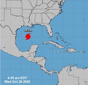
Hurricane Zeta Public Advisory
At 400 AM CDT, Zeta is moving toward the north-northwest near 17 mph (28 km/h). A turn toward the north is expected soon, and a faster northward to north-northeastward motion is expected to begin later this morning. On the forecast track, the center of Zeta will approach the northern Gulf coast this morning and make landfall in southeastern Louisiana this afternoon. Zeta will move close to the Mississippi coast this evening, and move across the southeastern and eastern United States on Thursday. >click to read< 07:30
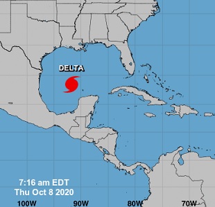
Hurricane Delta Public Advisory Notice
At 0700, Hurricane Delta is moving toward the north near 12 mph (19 km/h), and this motion is expected to continue today followed by a north-northeastward motion by tonight. On the forecast track, the center of Delta will move inland within the hurricane warning area this evening. Delta is a category 3 hurricane on the Saffir-Simpson Hurricane Wind Scale. Slow weakening is expected to begin as Delta approaches the northern Gulf coast later today, with rapid weakening expected after the center moves inland. >click to read< 08:15
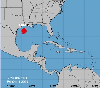
Hurricane Delta Public Advisory Notice
At 700 AM CDT, the center of Hurricane Delta was located by NOAA and Air Force Reserve Hurricane Hunter aircraft near latitude 23.7 North, longitude 92.3 West. Delta is moving toward the northwest near 15 mph (24 km/h), and this motion with a reduction in forward speed is expected today. A turn to the north is forecast to occur by late tonight, followed by a north- northeastward motion by Friday night. On the forecast track, the center of Delta will move over the central Gulf of Mexico today, and move inland within the hurricane warning area Friday afternoon or Friday night. >click to read< 08:10

Coast Guard urges caution to mariners ahead of heavy weather expected to impact the Central and Southern California Coast
Sunday’s weather conditions for the inner waters in the vicinity of metro Los Angeles include wind speeds reaching 40 knots and sea states as high as 14 feet. Conditions are expected to worsen moving north from Los Angeles. For offshore conditions, the National Weather Service is reporting potential gusts approaching 50 knots with seas nearing 20 feet. Beaches throughout the area are expected to feature exceptionally high surf, large breaking waves and dangerous rip currents.>click to read< 07:48

‘A major punch in the gut’: Midwest rains projected to create Gulf dead zone
As rain deluged the Midwest this spring, commercial fisherman Ryan Bradley knew it was only a matter of time before the disaster reached him. All that water falling on all that fertilizer-enriched farmland would soon wend its way through streams and rivers into Bradley’s fishing grounds in the Gulf of Mexico, off the Mississippi coast. The nutrient excess would cause tiny algae to burst into bloom, then die, sink, and decompose on the ocean floor. That process would suck all the oxygen from the water, turning it toxic. Fish would suffocate, or flee, leaving Bradley and his fellow fishermen with nothing to harvest. >click to read<21:12
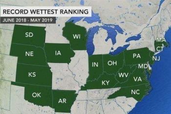
Drenched US documented its second-wettest May on record
While the continental United States recorded its wettest 12-month period in recorded history this year, historic flooding and record-shattering rainfall amounts landed May 2019 as the second-wettest month in the United States. Precipitation across the contiguous U.S. that accumulated over the June 2018 to May 2019 12-month period shattered the previous record for any 12-month period with 37.68 inches, 7.73 inches above average. “The previous June-May record was 35.47 inches and occurred from June 1982 to May 1983. The previous all-time 12-month record was 36.20 inches and occurred from May 2018 to April 2019,” Reppert said. (not a mention of climate change!)>click to read<14:42
Reeling for Weather
Dave Bitts has been trolling the Pacific waters off the North Coast for decades. “I almost have been making a living out of it for 40 years,” said Bitts. The hum of Elmarue, his 45-foot fishing boat, is often dwarfed by the sounds of his chuckles and his enthusiasm for reeling in the catch of the day. Although semi-retired, Bitts finds any excuse he can to take his boat out on the water.,, Just a few minutes into the trip, Bitts airs his concerns about what he is not seeing. “We should be having big southerlies, big seas, and lots of rain this month. And it’s not happening,” said Bitts. >click to read<13:32
Coast Guard warns mariners, prepares for storm, New Jeresey and North, Hurricane Force Wind Warning for Coastal NE
The Coast Guard is advising mariners and swimmers along the New York and New Jersey coasts to use caution as a powerful storm approaches Thursday night through Saturday. Mariners are warned to take the following precautions to protect their vessels and their crews: “With the potential for severe weather, our overall concern is ensuring the safety of the people and mariners who live and work on the water,” said Capt. Jason Tama >click to read< 17:27
HURRICANE FORCE WIND WARNING IN EFFECT FROM FRIDAY AFTERNOON THROUGH SATURDAY MORNING
National Weather Service – 417 PM EST Thu Mar 1 2018 .Synopsis for Massachusetts and Rhode Island coastal waters… A powerful and long duration coastal storm gets underway tonight into Sat, and perhaps lingers into Sun. >click to read<17:35

Senate panel clears Trump’s nominee for NOAA
The Senate Commerce Committee voted Wednesday to move forward with the nomination of Barry Myers to be head of the National Oceanic and Atmospheric Administration (NOAA). The 14-13 vote, along party lines, puts Myers in a position for a vote in the full Senate. Myers was until recently the CEO of AccuWeather Inc., which he founded with his brother. The weather forecasting company provides products similar to some NOAA services such as the National Weather Service, leading to concerns among Democrats that Myers is unacceptably conflicted. click here to read the story 14:30
Hurricane Harvey Downgraded to Tropical Storm Over Inland Texas
 At 100 PM CDT (1800 UTC), the center of Tropical Storm Harvey was located by National Weather Service Doppler radar near latitude 29.1 North, longitude 97.6 West. Harvey is moving slowly toward the north-northwest near 2 mph (4 km/h), and little motion is anticipated during the next several days. Maximum sustained winds have decreased to near 70 mph (110 km/h) with higher gusts. Additional weakening is forecast during the next 48 hours. click here to read the update 15:33
National Weather Service suffers ‘catastrophic’ outage, stops sending forecasts, warnings
On a day when a blizzard was pasting Maine and northern California faced a dire flooding threat, several of the National Weather Service’s primary systems for sending out alerts to the public failed for nearly three hours. Between approximately 1:15 p.m. and 4 p.m. Eastern time Monday, products from the Weather Service stopped disseminating over the internet, including forecasts, warnings and current conditions. At about 4 p.m. Monday, a Weather Service spokesperson said the “system just came back up” and that more information about the cause of the outage was forthcoming. During the outage, the Weather Service’s public-facing website, Weather.gov, no longer posted updated information. Ryan Hickman, chief technology officer for AllisonHouse, a weather data provider, called the situation “catastrophic.” Continue reading the story here 08:53
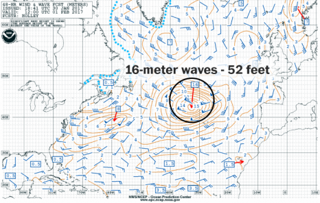
Monster winter storm expected to churn up 50-foot waves in the open Atlantic
A monster winter storm is taking shape along the East Coast this week, and the National Weather Service is calling for 50-foot waves in the Atlantic by Tuesday. That’s not just a shot-in-the-dark — if you add up all of the forecast data, there’s over a 90 percent chance that wave heights will exceed 30 feet. This storm is the same trough of low pressure that dipped into the Mid-Atlantic on Sunday and dropped a few inches of snow in the D.C. area. On Monday morning, the storm was just 1005 millibars — barely a low pressure system at all. But over the next 48 hours, the storm is expected to drop to 968 millibars. On its southern side, winds will easily reach Category 1 hurricane-strength. That will churn up waves of 16 meters, which is around 50 feet — at least that’s what the Ocean Prediction Center is forecasting. They’re calling the storm “extremely dangerous low pressure.” Click here for more imagery 13:55
Alaska Bearing Sea snow Crab Season Shaping Up As Less Icy
 After a 2012 Bering Sea snow crab season that saw unusually severe sea ice inhibit fishermen’s efforts to catch almost 89 million pounds of the shellfish, 2013 is shaping up to be much friendlier. According to Kathleen Cole, a forecaster with the National Weather Service ice desk, this winter was unlikely to match 2012, even before it began. Despite some recent rumors of encroaching ice into the Bering Sea fishery, the situation is better than last year, she said. “We’re just not going to have a year like last year. It’s going to be, by no means, that bad,” she said. “Last year was something that we’d never seen before, and hopefully something that we’ll never see again.” Read more