Tag Archives: satellite footprint
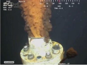
‘Invisible oil’ from Deepwater Horizon spill may have reached the Florida Keys, possibly as far as North Carolina
Nearly a decade after the worst offshore oil spill in U.S. history killed 11 people and dumped 200 million gallons of crude into the ocean, researchers found discrepancies in the satellite footprint that was used to establish fisheries closures and data from sampling and field tests. They concluded that the real extent of the BP oil spill may have been 30 percent larger than originally estimated.,,, “We realized that the satellite footprint and the fisheries closure areas didn’t capture the full extent of the spill, and that the impact on marine life may have been overlooked,“ >click to read< 07:40