Tag Archives: aerial survey
Mass DMF – Effective May 14, Seasonal Trap Gear Closure and Speed Restrictions Lifted
Beginning tomorrow, commercial trap fishermen may set their gear in those waters under the jurisdiction of the Commonwealth east and north of Cape Cod up to the New Hampshire border. These waters have been closed to trap gear fishing since February 1. Additionally, mariners operating vessels less than 65’ overall length may run them at speeds greater than 10 knots. Operators of vessels with an overall length of 65’ or greater are reminded the federal 10 knot speed limit remains in effect in Cape Cod Bay Seasonal Management Area through May 15. >click to read< 18:36

Trap Gear Closure and Speed Limit in Cape Cod Bay Lifted Today (Tuesday, May 15, 2018)
May 14, 2018 Aerial Survey shows that right whales have departed Cape Cod Bay The Provincetown Center for Coastal Studies (PCCS) conducted an aerial survey of Cape Cod Bay yesterday (Monday, May 14, 2018) as part of DMF’s ongoing right whale conservation efforts. Clear weather conditions allowed PCCS’ aerial survey team to complete an entire survey of the Bay and no right whales were observed in the Bay. Consequently, DMF has lifted its emergency regulatory closure on the setting of lobster traps and the speed limit of 10 knots or less on small vessels (smaller than 65’) in Cape Cod Bay effective today, Tuesday May 15, 2018. >click to read<11:03
Biologists expect early 2018 Togiak herring run
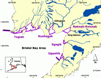
This year, Togiak could see one of the earliest herring harvests ever recorded. “We’re going to fly our first survey on Friday. And then I expect we’ll be seeing herring by [April] 20th, if not sooner,” said Alaska Department of Fish and Game area biologist Tim Sands. That would be the Togiak fishery’s second-earliest start on record. The earliest recorded date a biomass was spotted in the district was April 14, 2016. But because of the unusual timing, fishing only began three days later. Herring spawn timing depends largely on water temperature >click to read<16:06


