Tag Archives: Hurricane Matthew
Beaufort community helped save this seafood institution.
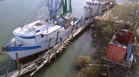
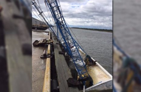
It’s officially a community barn-raising. An effort to raise money and rebuild a Beaufort County seafood institution spread in recent weeks with the help of volunteers and social media. Now the first sections of Gay Fish Co.’s storm-ravaged docks can be rebuilt in time for shrimp season. Organizers expect work to begin the first week of April and finish by June. “Everybody is convinced now it’s going to happen,” said dock builder Richard Knieriem, who is volunteering to oversee the construction. >click to read< 09:07
Shrimp size on the rise after Hurricane Matthew
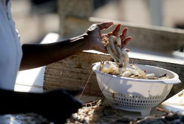 In the midst of fallen trees and other debris, Hurricane Matthew left a sweet little calling card: shrimp, big ones. The storm’s rain and river flooding evidently washed large white shrimp out to the commercial grounds offshore, at least in spots, and some commercial boats are reporting some of the biggest shrimp of the season, hoisting their optimism in a year that’s had its ups and downs. The current cold snap evidently slowed down the catch somewhat. But shrimpers expect it to come back and are looking forward to another big run before frigid winter weather sets in. Shem Creek shrimper Tommy Edwards didn’t net much offshore on Monday, after pulling in hundreds of pounds per day on recent trips. But he expected that to change mid-week, and “the big white shrimp are looking beautiful right now,” he said. “Oh yeah, they’re gorgeous,” Tina Toomer of the Bluffton Oyster Co., said about the catch her husband, Larry Toomer, has been bringing in. Read the story here 13:58
Shrimpers with chainsaws: Local commercial fishermen carry on after Hurricane Matthew
 October is supposed to be a month for prime Lowcountry seafood but this month, Hurricane Matthew had other plans. The Category 2 storm put local seafood production on hold. The storm hit Beaufort County just a week after the start of the oyster season and in the middle of shrimp season. But not to worry. Most local fishermen stayed with their vessels through the storm and — with the resilience the trade has always required — are making their way to recovery. “A chainsaw becomes necessary equipment on a shrimp boat now,” Reeves said. “Anything you can imagine, we see: pilings, lawn chairs, refrigerators. Cutting through can be difficult and very costly.” The long-term impact on local shrimp populations is also still not clear, local shrimpers say. Read the story here 14:01
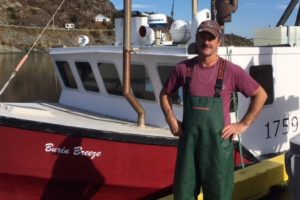
S.C. couple rode out Matthew on their shrimp boat
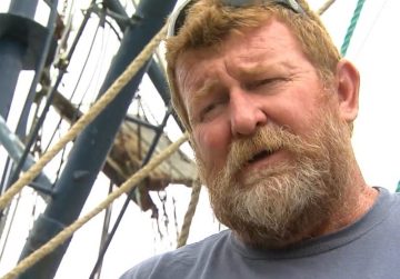
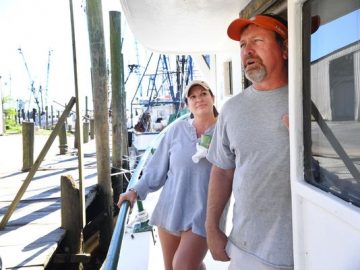 Richard Billington, who was aware of the storm and had taken special precautions with his boat, Village Lady, said the couple did not have cell phone service and they had lost power so they weren’t sure where the storm was. Unbeknownst to them, the hurricane was aiming for a landfall near McClellanville, the same spot where Hurricane Hugo made landfall in 1989 with a 20-foot storm surge and devastating consequences. “We came down here to make coffee and cook breakfast and all of a sudden the storm surge came in and we couldn’t get off,” he said. “The most amazing thing was right during the worst of it, I looked across the creek at a dock and there was about 20 seagulls with 95 to 110 mph winds blowing and the seagulls were still holding onto the dock,” he said. He also noticed an army of bugs coming out of the water and climbing onto the pilings. Read the story here 08:33
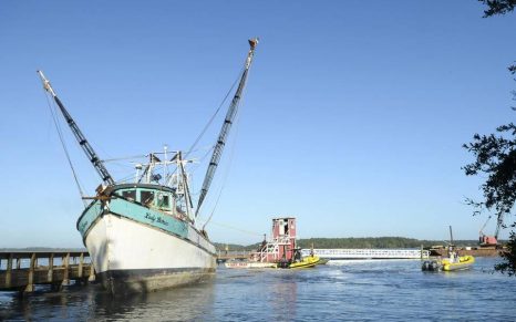
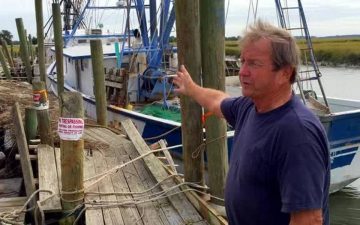
Fundraiser hopes to keep F/V Lady Bernice shrimp trawler working after Hurricane Matthew
The Lady Bernice shrimp trawler was set free Monday after Hurricane Matthew wedged the 80-ton shrimp boat in the mud of Hilton Head Island’s Skull Creek. But all is still not well with the Lady. There was other damage that may risk the future of one of the few shrimp boats still working near Hilton Head. After the boat was freed, longtime shrimp boat captain Charles Abner discovered that his trawler lost all electronics and that the radar system needed to navigate on the boat was damaged. The boat also suffered a broken propeller, shattered window and cosmetic damages to its side. Capt. Abner hopes the boat is still able to go on short shrimping trips, but knows it would be unsafe to go out longer. “I still fully intend to go out shrimping on Thursday,” Capt. Abner said. “We’ll see if it works then.” Read the story here To donate to help keep the “Lady Bernice” runnning, go to the “Save Lady Bernice” page at GoFundMe.com. 07:59
North Carolina’s seafood deliveries continue in wake of Hurricane Matthew
 While the flooding continues in North Carolina and portions of major highways remain closed, seafood distributors and wholesalers in the state are continuing to make deliveries following Hurricane Matthew’s landfall. “It is challenging to get to some places, but overall, we are getting our orders out. Our drivers are finding ways to do it,” said a source with the Charlotte, N.C, office for Inland Seafood, a major seafood distributor based in Atlanta. Major portions of Interstate 95 and Interstate 40 are still closed, causing headaches for seafood deliveries to restaurants and retailers. And some businesses along the N.C. coast were without power until 11 October and 12 October. “We were spared with the winds, but with all that water coming in – and rivers at a record high –we dealing with the aftermath,” said Lin Peterson, co-owner of Raleigh, N.C.-based Locals Seafood, a wholesaler, retailer and community supported fishery (CSF). “We just focus on seafood off the N.C. coast, so we are really affected when this happens.” Read the story here 11:49
Coast Guard battles to reopen Georgia ports after hurricane Matthew
When Hurricane Matthew hit the Georgia coastline over the weekend, high winds damaged navigational signs and buoys, shutting down the state’s busiest ports. Now, the Coast Guard is working to reopen ports in Savannah and Brunswick. Tuesday, the Coast Guard was battling through damage to navigational aids, infrastructure and vessels along the waterways. Before the ports can reopen, they’ll have to fix 50 navigational aids and several major navigational buoys that were damaged, destroyed or moved by the storm. Ten boat crews from Georgia, Florida and South Carolina are leading the efforts in repairing these aids.Two 225-foot Seagoing Buoy Tenders, the Cutter Anvil from Miami and the Cutter Cypress from Pensacola are also headed to Savannah to help recovery efforts. Images, Read the rest here 14:04

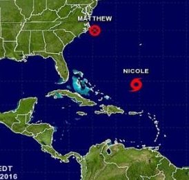
Post-Tropical Cyclone Matthew Tropical Storm Warning is in effect for Cape Fear to Duck, Pamlico and Albemarle Sounds
A Hurricane Watch is in effect for… North of Surf City to Duck Pamlico and Albemarle Sounds A Tropical Storm Warning is in effect for… Cape Fear to Duck Pamlico and Albemarle Sounds. A Hurricane Watch means that hurricane conditions are possible within the watch area, in this case within the next 6 to 12 hours. The center of Post-Tropical Cyclone Matthew was located near latitude 35.0 North, longitude 74.5 West. Matthew is moving toward the east-northeast near 14 mph (22 km/h). A motion toward the east-northeast or east is expected for the next couple of days. On the forecast track, the center of Matthew will move farther offshore of the coast of the North Carolina Outer Banks today and tonight. Read the update here 09:43
Oct 8, 20:00 Hurricane Matthew – Center now east of Cape Fear, record breaking flooding developing over eastern N.C.
At 800 PM EDT (0000 UTC), the center of Hurricane Matthew waslocated near latitude 33.8 North, longitude 77.3 West. Matthew is moving toward the east-northeast near 13 mph (20 km/h), and this motion is expected to continue tonight and early Sunday. On the forecast track, the center of Matthew will be near the coast of southern North Carolina by this evening. Maximum sustained winds remain near 75 mph (120 km/h) with higher gusts. While Matthew is expected to remain near hurricane strength while the center is near the North Carolina coast, the system could become a post-tropical cyclone later tonight or on Sunday. STORM SURGE: The combination of a dangerous storm surge, the tide, and large and destructive waves will cause normally dry areas near the coast to be flooded by rising waters moving inland from the shoreline. The water could reach the following heights above ground if the peak surge occurs at the time of high tide… Murrells Inlet, South Carolina, to Duck, North Carolina, including portions of the Pamlico and Albemarle Sounds…3 to 5 ft Read the update here 20:18
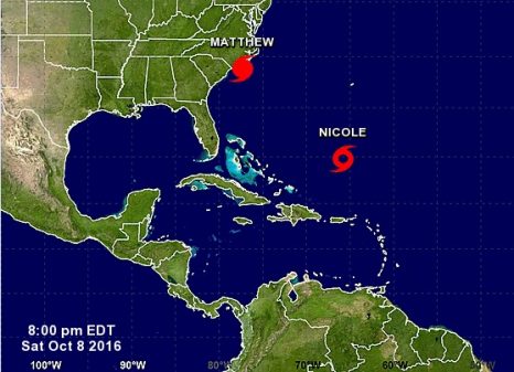
Oct 8, 0800 Hurricane Matthew – strong winds and dangerous storm serge affecting coast of South Carolina
At 800 AM EDT (1200 UTC), the center of Hurricane Matthew was located by NOAA Doppler weather radars, and an Air Force Reserve Hurricane Hunter aircraft, near latitude 32.5 North, longitude 79.8 West. Matthew is moving toward the northeast near 12 mph (19 km/h), and this general motion is expected to continue today. On the forecast track, the center of Matthew will continue to move near or over the coast of South Carolina today, and be near the coast of southern North Carolina by tonight. Reports from the reconnaissance aircraft indicate that maximum
sustained winds have decreased to near 85 mph (140 km/h) with higher gusts. Although weakening is forecast during the next 48 hours, Matthew is expected to remain a hurricane while the center is near the coasts of South Carolina and North Carolina. Read the update here 08:33
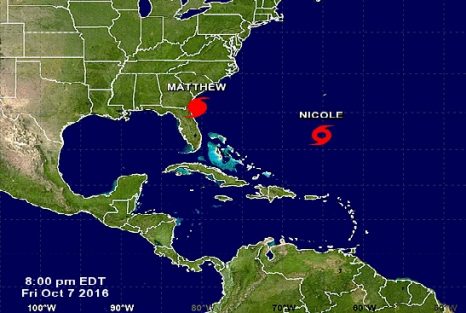
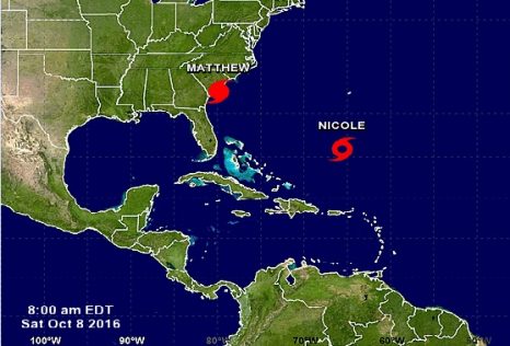
Oct 7, 20:00 EYE OF HURRICANE MATTHEW MOVING NORTHWARD OFF THE COASTS OF GEORGIA AND NORTHEASTERN FLORIDA
At 800 PM EDT (0000 UTC), the eye of Hurricane Matthew was located near latitude 30.7 North, longitude 80.6 West. Matthew is moving toward the north near 12 mph (19 km/h), and this motion is expected to continue tonight. A turn toward toward the north-northeast and then to the northeast is expected on Saturday. On the forecast track, the center of Matthew will continue to move near or over the coast of northeast Florida and Georgia through tonight, and near or over the coast of South Carolina on Saturday. Maximum sustained winds are near 110 mph (175 km/h) with higher gusts. Although weakening is forecast during the next 48 hours, Matthew is expected to remain a hurricane until it begins to move away from the southeastern United States on Sunday. Read the update here 20:23
Stay, or Go. McClellanville Fishermen face tough decision as Hurricane Matthew approaches
 Hurricane Hugo just devastated the sleepy fishing village of McClellanville, but they rebuilt and started fishing again. The community has since weathered several storms. As Hurricane Matthew approaches, fishermen have some of the toughest decisions to make. “I have a house but i stay on my boat,” said shrimp boat captain Timmy Glines. “I don’t have insurance, a lot of money invested and i don’t want to lose it.” Glines will stay but he knows the destruction Hugo caused firsthand “It was very scary,” Glines said. “I don’t want to do it again, ever ever. This is just a bit less, if it was 150 mph, I’d get out of here.” The big question for the captains here– should I stay or should I go. The docks in McClellanville look like the back of an entertainment center — boats and ropes tied up so tightly — some captains staying, others will go. Video, Read the story here 06:57
Oct 6, 2016 17:00 EDT – Hurricane Matthew Approaching the Southeast U.S. Coast
The Latest on Hurricane Matthew 0:500 EDT THU OCT 06 2016
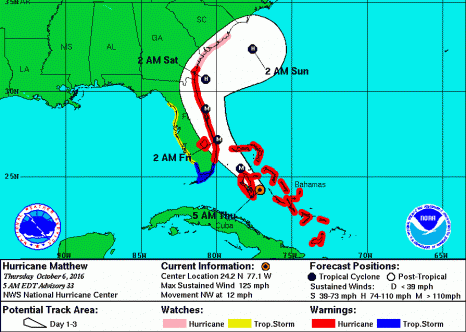
CHANGES WITH THIS ADVISORY: The Hurricane Warning has been extended northward to Altamaha Sound, Georgia, and the Hurricane Watch has been extended northward to South Santee River, South Carolina. At 500 AM EDT (0900 UTC), the center of Hurricane Matthew was located near latitude 24.2 North, longitude 77.1 West. Matthew is moving toward the northwest near 12 mph (19 km/h), and this general motion is expected to continue today. A turn toward the north-northwest is expected tonight. On the forecast track, the eye of Matthew should pass near Andros Island and New Providence in the northwestern Bahamas early this morning, then pass near Grand Bahama Island late today, and move very close to the east coast of the Florida peninsula tonight through Friday night. Read the advisory here 07:18 Be prepared.
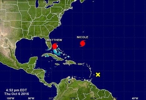
The Latest BULLETIN HURRICANE MATTHEW – 800 AM EDT WED OCT 05 2016
At 800 AM EDT (1200 UTC), the center of Hurricane Matthew was located near latitude 21.5 North, longitude 74.9 West. Matthew is moving toward the north-northwest near 10 mph (17 km/h). This motion is expected to continue today, followed by a northwestward turn tonight. On this track, Matthew will be moving across the Bahamas through Thursday, and is expected to be very near the east coast of Florida by Thursday evening. Read the update here You can reach the National Weather Service by scrolling down the page and clicking on the NWS icon. 08:34
Hurricane Matthew Warnings Shift Toward Florida, Gov. Rick Scott declares a State of Emergency
At 800 AM EDT (1200 UTC), the eye of Hurricane Matthew was located inland Haiti near latitude 18.4 North, longitude 74.2 West. Matthew made landfall near Les Anglais about 700 AM EDT (1100 UTC). The hurricane is moving toward the north near 9 mph (15 km/h), and this general motion is expected to continue today. On this track the eye of Matthew will be back over water in the Gulf of Gonave in the next hour or so, and then move over the Windward Passage later this morning. A turn toward the north-northwest is expected by Wednesday, followed by a northwest turn Wednesday night. Read the rest here The alert warns that Matthew is expected to make a northwestern turn on Wednesday — and that hurricane-force winds are expected to reach up to 40 miles out from the eye of the storm. Meteorologists say Matthew is currently gusting 140 mph winds near its eye wall. Just before the warning was issued, Gov. Rick Scott declared a state of emergency in every county in Florida 09:41
Hurricane Matthew continues slowly tracking northwest as Category 4 storm
The Category 4 Hurricane Matthew continues to move slowly on a northwesterly track through the Caribbean Sea, but is expected to turn toward the north Sunday night (Oct. 2) before bearing down on southwestern Haiti and Jamaica on Monday, according to the latest forecast from the National Hurricane Center. At 7 a.m. Sunday, Matthew’s center was within 340 miles of both Port-Au-Prince, Haiti, and Kingston, Jamaica. The storm was moving at approximately 5 mph, with maximum sustained winds clocked at 150 mph amid higher gusts. Forecasters do not expect Matthew to enter the Gulf of Mexico or pose a threat to Southeast Louisiana, but the storm is expected to impact weather along the eastern seaboard of the United States later next week. Read the story here 11:28