


Flying over Sears Island puts the offshore wind debate in context
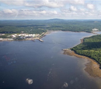 A bird’s-eye view can show you a lot about a place — its size and shape, its hidden contours, and the water, forests, roads and development around it. I got this landscape-level view of part of Penobscot Bay last week. I flew in a small propeller plane between Belfast, Searsport and Stockton Springs, up to the mouth of the Penobscot River where it flows from Bucksport around Verona Island, and back again. On my Penobscot Bay flight, we flew from Belfast’s tiny airstrip out over Sears Island, which is mostly undeveloped but still accessible by road. We could see the part of the island where the state wants to build the wind port, an area about one tenth the island’s size. Mack Point is where opponents of the Sears Island project say they want the port built. It was considered by the state’s Offshore Wind Port Advisory Group over the past two years. Sprague has since proposed a new approach to using the site for the port, which groups like Friends of Sears Island are pushing for. Photos, more, >>CLICK TO READ<< 08:53


“offshore wind development would help us use more electric home heating without less added emissions from the power grid “. Not true. OSW and Solar do not diminish Fossil Fuels. FF plants are on-line, ramping up and down instantaneously to cover lulls in W&S that operatre about 40 % of the time. W&S “droughts” of weeks require either FF generators or battery back up of weeks – the latter completely impossible with today’s best technologies.