


Hurricane Francine is predicted to make landfall west of New Orleans
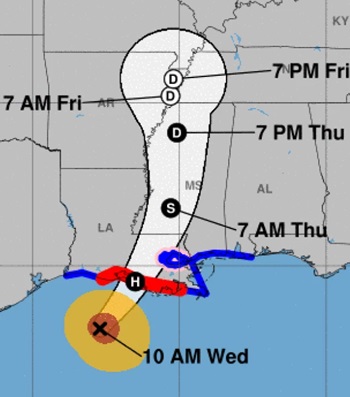 Hurricane Francine is crossing over warm waters in the western Gulf of Mexico, and it has Louisiana’s coast — and the greater New Orleans area — in its sights, according to the National Hurricane Center’s latest forecast. The storm became a hurricane Tuesday night; its maximum sustained winds are now topping 90 mph. As of 10 a.m. CT, Francine was about 150 miles southwest of Morgan City, La., moving northeast at 13 mph. “Francine is anticipated to make landfall in Louisiana … late this afternoon or evening,” the hurricane center said on Wednesday. If the storm surge coincides with high tide, water could reach 5 to 10 feet above ground in areas from Louisiana’s Intracoastal City and Vermilion Bay to Port Fourchon. The hurricane’s outer bands of rain began hitting Lafayette, Baton Rouge and other areas in southern Louisiana Wednesday morning. In the gulf, an oil platform north of the center recently reported a peak gust of 105 mph, the NHC said. more, >>CLICK TO READ<< 14:21


Leave a Reply