Tag Archives: Hurricane Maria

U.S. Secretary of Commerce Declares Fisheries Disasters Following Hurricanes Irma and Maria
Today, in conjunction with the requests put forward by the Governors of Florida, the U.S. Virgin Islands, and Puerto Rico, Secretary of Commerce Wilbur Ross determined catastrophic fishery disasters occurred in the areas because of impacts from Hurricanes Irma and Maria that made landfall in August and September of 2017. Under the Interjurisdictional Fisheries Act and the Magnuson-Stevens Fishery Conservation and Management Act, the Governors asked the Secretary of Commerce to determine whether a commercial fishery failure occurred due to a fishery resource disaster, in these cases caused by destructive hurricanes. >click to read< 12:25
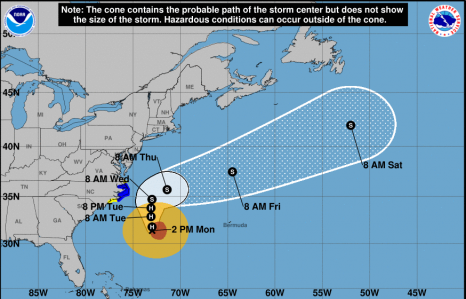
Hurricane Maria Public Advisory 0800 AM EDT Update
At 800 AM EDT, the center of Hurricane Maria was located near latitude 33.3 North, longitude 73.1 West. Maria is moving toward the north near 7 mph (11 km/h), and this general motion with some decrease in forward speed is expected through tonight. A turn toward the north-northeast is expected on Wednesday. On the forecast track, the center of Maria will pass east of the coast of
North Carolina during the next couple of days. click here to read the update 08:59
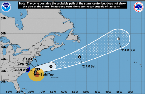
Hurricane Maria Public Advisory 200 PM EDT
At 200 PM EDT, the center of Hurricane Maria was located near latitude 31.4 North, longitude 73.0 West. Maria is moving toward the north near 7 mph (11 km/h), and this general motion with some decrease in forward speed is expected through Tuesday night. On the forecast track, the center of Maria will move well east of the southeast coast of the United States during the next day or so. click here to read the update 14:04
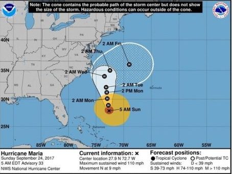
Hurricane Maria path: Category 2 storm may get uncomfortably close to East Coast before turning
A weaker Hurricane Maria continued on a path northward off the U.S. East Coast on Sunday. The National Hurricane Center said Maria, a Category 2 hurricane with sustained winds of 110 mph, will continue to track northward parallel to the coast before making a turn away from land and to the east. It’s where and when that turn will happen that is problematic. Forecasters think the core of the hurricane will stay offshore, but it could come close enough that parts of the coast will feel some of its effects. For that reason, the hurricane center said tropical storm — or hurricane — watches may be issued for parts of the North Carolina or Mid-Atlantic coasts today. click here to read the story 10:48
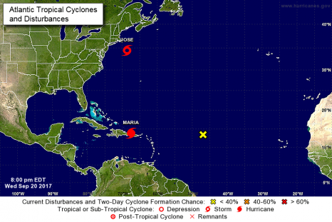
The Latest – Hurricane Maria and Tropical Storm Jose Updates 800 PM AST
At 800 PM AST, the center of Tropical Storm Jose was located near latitude 39.4 North, longitude 68.6 West. Jose is moving toward the northeast near 8 mph (13 km/h), and this general motion with a decrease in forward speed is expected through tonight. A slow westward motion should begin by Thursday night. On the forecast track, the center of Jose is expected to meander off the coast of southern New England during the next few days. click here to read the advisory
At 800 PM AST (0000 UTC), the eye of Hurricane Maria was located by an Air Force reconnaissance aircraft near latitude 18.9 North, longitude 67.5 West. click here to read the advisory 20:23
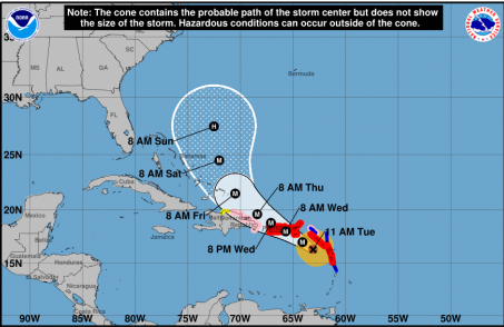
National Hurricane Center – Hurricane Maria Public Advisory
At 1100 AM AST, the eye of Hurricane Maria was located near latitude 16.3 North, longitude 63.1 West. Maria is moving toward the west-northwest near 10 mph (17 km/h), and this general motion is expected to continue through Wednesday night. On the forecast track, the eye of Maria will move over the northeastern Caribbean Sea today, and then pass near or over the Virgin Islands and Puerto Rico on Wednesday. Maximum sustained winds are near 160 mph (260 km/h) with higher gusts. Maria is a potentially catastrophic category 5 hurricane click here to read the update 11:23